Backnang night lights from space
Night Light of Backnang (Baden-Württemberg) from space (Germany) Src. Average luminocity for 10x10km area is 14.3139% and for 50x50km: 19.2395%.

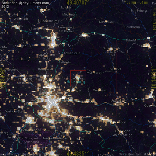
Analysis of Backnang night lights 2016
Square area 10x10 km:
 0.71%
0.71%90-99
2.13%80-89
1.56%70-79
1.56%60-69
1.42%50-59
1.14%40-49
2.98%30-39
2.7%20-29
3.41%10-19
11.65%0-9
70.74%Square area 50x50 km:
3.5%90-99
3.62%80-89
1.48%70-79
2.17%60-69
2.61%50-59
2.69%40-49
2.87%30-39
3.24%20-29
4.38%10-19
10.11%0-9
63.32%Clear (daylight) street map image can be seen on geolist.org.
Map coordinates:
49° 24' 25.5" North, 8° 44' 2.6" East
48° 56' 50.7" North, 9° 26' 13.8" East
48° 29' 0.6" North, 10° 8' 25.1" East
Some cities around Backnang sort by population:
• Winnenden
8.5 km =5.3 mi,  199°
199°
• Murrhardt
10.5 km =6.5 mi,  68°
68°
• Rudersberg
9.7 km =6 mi,  135°
135°
• Leutenbach
7.4 km =4.6 mi,  206°
206°
• Schwaikheim
10.1 km =6.3 mi,  219°
219°
• Aspach
3.5 km =2.2 mi,  308°
308°
• Mittelschöntal
3.1 km =1.9 mi,  267°
267°
• Sulzbach an der Murr
7.7 km =4.8 mi,  36°
36°
2953568 (p: 35,778)
Sources (retrieved 2019-11-25):
» Earth at Night: Flat Maps 2012, 2016