Aspach night lights from space
Night Light of Aspach (Baden-Württemberg) from space (Germany) Src. Average luminocity for 10x10km area is 14% and for 50x50km: 19.5932%.
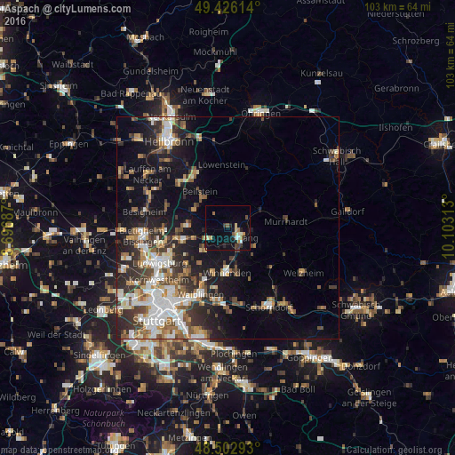
Analysis of Aspach night lights 2016
Square area 10x10 km:
 0.71%
0.71%90-99
2.13%80-89
2.27%70-79
2.13%60-69
1.7%50-59
1.14%40-49
1.42%30-39
2.13%20-29
2.98%10-19
6.96%0-9
76.42%Square area 50x50 km:
3.51%90-99
3.64%80-89
1.55%70-79
2.21%60-69
2.59%50-59
2.68%40-49
2.86%30-39
3.36%20-29
5.3%10-19
10.17%0-9
62.13%Clear (daylight) street map image can be seen on geolist.org.
Map coordinates:
49° 25' 34.1" North, 8° 41' 48.7" East
48° 58' 0" North, 9° 24' 0" East
48° 30' 10.5" North, 10° 6' 11.3" East
Some cities around Aspach sort by population:
• Backnang
3.5 km =2.2 mi,  128°
128°
• Winnenden
10.1 km =6.3 mi,  180°
180°
• Steinheim am der Murr
9 km =5.6 mi,  271°
271°
• Leutenbach
8.8 km =5.5 mi, 183°
• Großbottwar
8.7 km =5.4 mi,  296°
296°
• Oberstenfeld
8.8 km =5.5 mi,  318°
318°
• Mittelschöntal
2.3 km =1.4 mi,  188°
188°
• Sulzbach an der Murr
8.4 km =5.2 mi,  61°
61°
3206150 (p: 8,131)
Sources (retrieved 2019-11-25):
» Earth at Night: Flat Maps 2012, 2016