Höchst im Odenwald night lights from space
Night Light of Höchst im Odenwald (Hesse) from space (Germany) Src. Average luminocity for 10x10km area is 1.1484% and for 50x50km: 7.2199%.
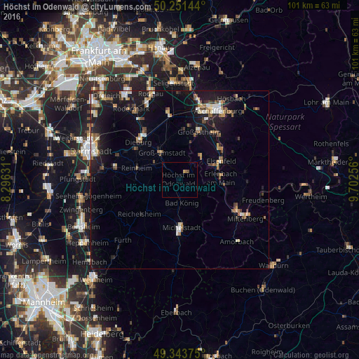
Analysis of Höchst im Odenwald night lights 2016
Square area 10x10 km:
 0%
0%90-99
0%80-89
0.53%70-79
0%60-69
0.53%50-59
0%40-49
0.53%30-39
0%20-29
0%10-19
0%0-9
98.4%Square area 50x50 km:
0.79%90-99
0.99%80-89
0.78%70-79
0.66%60-69
1.08%50-59
0.8%40-49
1.16%30-39
0.72%20-29
1.68%10-19
7.12%0-9
84.23%Clear (daylight) street map image can be seen on geolist.org.
Map coordinates:
50° 15' 5.2" North, 8° 17' 46.7" East
49° 47' 59" North, 8° 59' 58" East
49° 20' 37.5" North, 9° 42' 9.2" East
Some cities around Höchst im Odenwald sort by population:
• Groß-Umstadt
9.1 km =5.7 mi,  327°
327°
• Reinheim
12.2 km =7.6 mi,  285°
285°
• Erlenbach am Main
11.8 km =7.3 mi,  87°
87°
• Bad König
6.3 km =3.9 mi,  174°
174°
• Obernburg am Main
10.3 km =6.4 mi,  66°
66°
• Elsenfeld
12.7 km =7.9 mi, 67°
• Brensbach
8.7 km =5.4 mi,  250°
250°
• Mömlingen
9 km =5.6 mi,  42°
42°
2902951 (p: 10,010)
Sources (retrieved 2019-11-25):
» Earth at Night: Flat Maps 2012, 2016