Meuselwitz night lights from space
Night Light of Meuselwitz (Thuringia) from space (Germany) Src. Average luminocity for 10x10km area is 1.3529% and for 50x50km: 5.3403%.
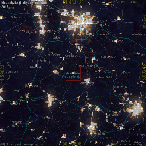
Analysis of Meuselwitz night lights 2016
Square area 10x10 km:
 0%
0%90-99
0%80-89
0%70-79
0.53%60-69
0.53%50-59
0.53%40-49
0%30-39
0%20-29
0%10-19
1.07%0-9
97.33%Square area 50x50 km:
0.66%90-99
0.82%80-89
0.47%70-79
0.57%60-69
0.66%50-59
0.8%40-49
0.45%30-39
0.68%20-29
0.48%10-19
4.14%0-9
90.26%Clear (daylight) street map image can be seen on geolist.org.
Map coordinates:
51° 28' 59.2" North, 11° 35' 46.4" East
51° 2' 35.3" North, 12° 17' 57.7" East
50° 35' 56.3" North, 13° 0' 8.9" East
Some cities around Meuselwitz sort by population:
• Altenburg
11.4 km =7.1 mi,  122°
122°
• Zeitz
11.4 km =7.1 mi,  273°
273°
• Borna
16.4 km =10.2 mi,  56°
56°
• Schmölln
16.7 km =10.4 mi,  166°
166°
• Hohenmölsen
18.9 km =11.7 mi,  312°
312°
• Frohburg
18.1 km =11.2 mi,  85°
85°
• Groitzsch
12.5 km =7.8 mi,  354°
354°
• Böhlen
18.5 km =11.5 mi,  19°
19°
2871437 (p: 9,625)
Sources (retrieved 2019-11-25):
» Earth at Night: Flat Maps 2012, 2016