Groitzsch night lights from space
Night Light of Groitzsch (Saxony) from space (Germany) Src. Average luminocity for 10x10km area is 4.0615% and for 50x50km: 10.7269%.
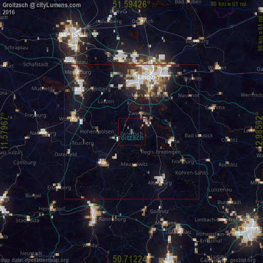
Analysis of Groitzsch night lights 2016
Square area 10x10 km:
 0.4%
0.4%90-99
0.4%80-89
0.53%70-79
0%60-69
0.53%50-59
0.27%40-49
0.67%30-39
1.2%20-29
0.53%10-19
0.67%0-9
94.79%Square area 50x50 km:
2%90-99
2.3%80-89
1.01%70-79
0.87%60-69
1.22%50-59
1.22%40-49
1.23%30-39
1.63%20-29
2.04%10-19
6.35%0-9
80.12%Clear (daylight) street map image can be seen on geolist.org.
Map coordinates:
51° 35' 39.3" North, 11° 34' 46.8" East
51° 9' 19.3" North, 12° 16' 58" East
50° 42' 44.1" North, 12° 59' 9.3" East
Some cities around Groitzsch sort by population:
• Zeitz
15.6 km =9.7 mi,  220°
220°
• Markkleeberg
14.6 km =9.1 mi,  24°
24°
• Borna
15.3 km =9.5 mi,  103°
103°
• Markranstädt
16.8 km =10.4 mi,  344°
344°
• Hohenmölsen
12.7 km =7.9 mi,  271°
271°
• Meuselwitz
12.5 km =7.8 mi,  174°
174°
• Zwenkau
7.8 km =4.8 mi,  25°
25°
• Böhlen
8.8 km =5.5 mi,  55°
55°
2917170 (p: 7,607)
Sources (retrieved 2019-11-25):
» Earth at Night: Flat Maps 2012, 2016