Metelen night lights from space
Night Light of Metelen (North Rhine-Westphalia) from space (Germany) Src. Average luminocity for 10x10km area is 0.2619% and for 50x50km: 7.1246%.
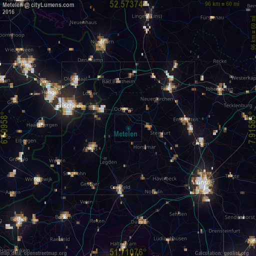
Analysis of Metelen night lights 2016
Square area 10x10 km:
 0%
0%90-99
0%80-89
0%70-79
0%60-69
0%50-59
0%40-49
0%30-39
0%20-29
0%10-19
0.53%0-9
99.47%Square area 50x50 km:
0.79%90-99
0.92%80-89
0.52%70-79
0.64%60-69
1.1%50-59
1.24%40-49
1.4%30-39
0.98%20-29
1.67%10-19
4.89%0-9
85.86%Clear (daylight) street map image can be seen on geolist.org.
Map coordinates:
52° 34' 25.5" North, 6° 30' 34.5" East
52° 8' 39.6" North, 7° 12' 45.7" East
51° 42' 38.7" North, 7° 54' 57" East
Some cities around Metelen sort by population:
• Steinfurt
8.5 km =5.3 mi,  85°
85°
• Ochtrup
7.2 km =4.5 mi,  347°
347°
• Heek
8.3 km =5.2 mi,  248°
248°
• Schöppingen
5.1 km =3.2 mi,  164°
164°
• Wettringen
10.2 km =6.3 mi,  45°
45°
• Horstmar
9.5 km =5.9 mi,  138°
138°
• Legden
14.5 km =9 mi,  211°
211°
• Laer
14 km =8.7 mi,  134°
134°
2871591 (p: 6,490)
Sources (retrieved 2019-11-25):
» Earth at Night: Flat Maps 2012, 2016