Legden night lights from space
Night Light of Legden (North Rhine-Westphalia) from space (Germany) Src. Average luminocity for 10x10km area is 0.9369% and for 50x50km: 5.9947%.
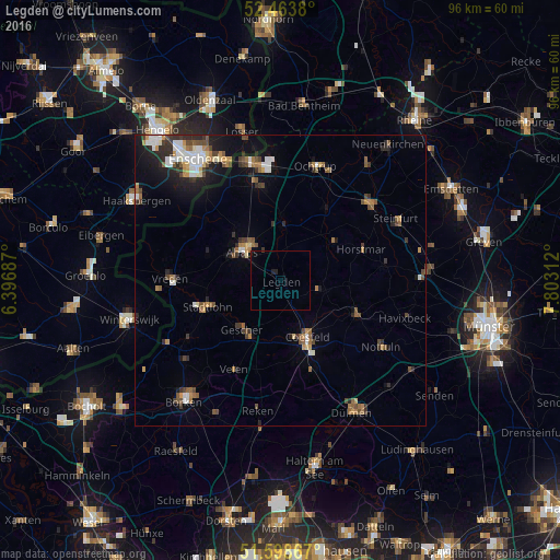
Analysis of Legden night lights 2016
Square area 10x10 km:
 0%
0%90-99
0%80-89
0%70-79
0%60-69
0.13%50-59
0%40-49
0%30-39
0.25%20-29
0.76%10-19
0.51%0-9
98.36%Square area 50x50 km:
0.77%90-99
0.88%80-89
0.37%70-79
0.63%60-69
0.93%50-59
0.97%40-49
1.05%30-39
0.98%20-29
1.46%10-19
3.07%0-9
88.89%Clear (daylight) street map image can be seen on geolist.org.
Map coordinates:
52° 27' 49.7" North, 6° 23' 48.7" East
52° 1' 60" North, 7° 6' 0" East
51° 35' 55.2" North, 7° 48' 11.2" East
Some cities around Legden sort by population:
• Ahaus
7.8 km =4.8 mi,  310°
310°
• Coesfeld
11 km =6.8 mi,  154°
154°
• Stadtlohn
13.1 km =8.1 mi,  250°
250°
• Gescher
11 km =6.8 mi,  216°
216°
• Billerbeck
14.5 km =9 mi,  114°
114°
• Heek
9.3 km =5.8 mi,  0°
0°
• Schöppingen
11.7 km =7.3 mi,  50°
50°
• Metelen
14.5 km =9 mi,  31°
31°
2879653 (p: 6,725)
Sources (retrieved 2019-11-25):
» Earth at Night: Flat Maps 2012, 2016