Laer night lights from space
Night Light of Laer (North Rhine-Westphalia) from space (Germany) Src. Average luminocity for 10x10km area is 1.077% and for 50x50km: 6.5555%.
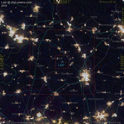
Analysis of Laer night lights 2016
Square area 10x10 km:
 0%
0%90-99
0%80-89
0%70-79
0%60-69
0.51%50-59
0%40-49
0.13%30-39
1.39%20-29
0%10-19
0%0-9
97.98%Square area 50x50 km:
0.79%90-99
0.93%80-89
0.31%70-79
0.68%60-69
1.05%50-59
1.24%40-49
1.19%30-39
0.96%20-29
1.35%10-19
3.43%0-9
88.07%Clear (daylight) street map image can be seen on geolist.org.
Map coordinates:
52° 29' 8.9" North, 6° 39' 16.7" East
52° 3' 20" North, 7° 21' 27.9" East
51° 37' 16" North, 8° 3' 39.2" East
Some cities around Laer sort by population:
• Steinfurt
10.6 km =6.6 mi,  352°
352°
• Nottuln
13.6 km =8.5 mi,  182°
182°
• Havixbeck
9 km =5.6 mi,  153°
153°
• Billerbeck
9.7 km =6 mi,  207°
207°
• Altenberge
7.5 km =4.7 mi,  94°
94°
• Nordwalde
9.1 km =5.7 mi,  70°
70°
• Schöppingen
9.8 km =6.1 mi,  300°
300°
• Horstmar
4.6 km =2.9 mi,  308°
308°
2881973 (p: 6,325)
Sources (retrieved 2019-11-25):
» Earth at Night: Flat Maps 2012, 2016