Mainburg night lights from space
Night Light of Mainburg (Bavaria) from space (Germany) Src. Average luminocity for 10x10km area is 4.0818% and for 50x50km: 4.4844%.
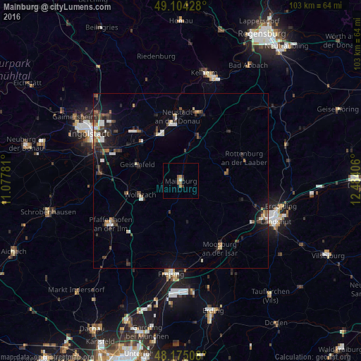
Analysis of Mainburg night lights 2016
Square area 10x10 km:
 0.3%
0.3%90-99
0.3%80-89
0.45%70-79
0.74%60-69
0.89%50-59
1.49%40-49
0.15%30-39
1.34%20-29
0.3%10-19
0%0-9
94.05%Square area 50x50 km:
0.57%90-99
0.67%80-89
0.29%70-79
0.33%60-69
0.45%50-59
0.6%40-49
0.87%30-39
0.87%20-29
1.34%10-19
2.53%0-9
91.47%Clear (daylight) street map image can be seen on geolist.org.
Map coordinates:
49° 6' 15.4" North, 11° 4' 40.1" East
48° 38' 30.6" North, 11° 46' 51.3" East
48° 10' 30.3" North, 12° 29' 2.6" East
Some cities around Mainburg sort by population:
• Neustadt an der Donau
18.4 km =11.4 mi,  357°
357°
• Wolnzach
12.2 km =7.6 mi,  249°
249°
• Geisenfeld
13.3 km =8.3 mi,  290°
290°
• Rottenburg an der Laaber
19.3 km =12 mi,  69°
69°
• Vohburg an der Donau
18.6 km =11.6 mi,  320°
320°
• Rohrbach
16 km =9.9 mi,  259°
259°
• Au in der Hallertau
9.7 km =6 mi,  197°
197°
• Nandlstadt
11.9 km =7.4 mi,  170°
170°
2874252 (p: 13,959)
Sources (retrieved 2019-11-25):
» Earth at Night: Flat Maps 2012, 2016