Au in der Hallertau night lights from space
Night Light of Au in der Hallertau (Bavaria) from space (Germany) Src. Average luminocity for 10x10km area is 0.3333% and for 50x50km: 5.1251%.
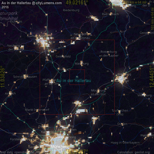
Analysis of Au in der Hallertau night lights 2016
Square area 10x10 km:
 0%
0%90-99
0%80-89
0%70-79
0%60-69
0%50-59
0%40-49
0%30-39
0.6%20-29
0%10-19
0.3%0-9
99.11%Square area 50x50 km:
0.92%90-99
0.95%80-89
0.33%70-79
0.35%60-69
0.46%50-59
0.48%40-49
0.76%30-39
0.84%20-29
1.6%10-19
3.05%0-9
90.26%Clear (daylight) street map image can be seen on geolist.org.
Map coordinates:
49° 1' 17.8" North, 11° 2' 17.7" East
48° 33' 30.2" North, 11° 44' 29" East
48° 5' 27.1" North, 12° 26' 40.2" East
Some cities around Au in der Hallertau sort by population:
• Freising
17.2 km =10.7 mi,  178°
178°
• Pfaffenhofen an der Ilm
17.7 km =11 mi,  259°
259°
• Moosburg
17.5 km =10.9 mi,  123°
123°
• Mainburg
9.7 km =6 mi,  17°
17°
• Wolnzach
9.9 km =6.2 mi,  300°
300°
• Geisenfeld
16.9 km =10.5 mi,  325°
325°
• Rohrbach
14.4 km =8.9 mi, 296°
• Nandlstadt
5.4 km =3.4 mi, 116°
2954088 (p: 5,427)
Sources (retrieved 2019-11-25):
» Earth at Night: Flat Maps 2012, 2016