Markranstädt night lights from space
Night Light of Markranstädt (Saxony) from space (Germany) Src. Average luminocity for 10x10km area is 20.4916% and for 50x50km: 16.2322%.
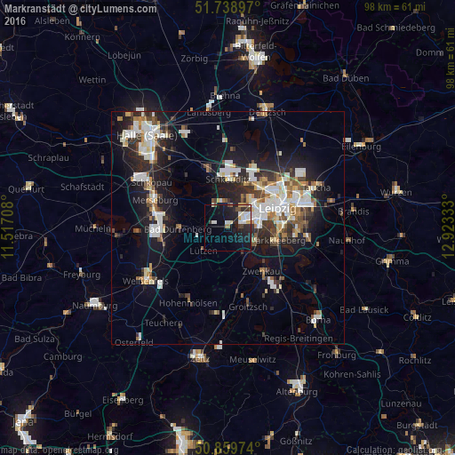
Analysis of Markranstädt night lights 2016
Square area 10x10 km:
 3.5%
3.5%90-99
5.32%80-89
1.26%70-79
1.54%60-69
1.26%50-59
1.12%40-49
1.68%30-39
2.52%20-29
6.72%10-19
21.57%0-9
53.5%Square area 50x50 km:
3.14%90-99
3.64%80-89
1.36%70-79
1.33%60-69
1.66%50-59
1.56%40-49
1.86%30-39
2.3%20-29
4.78%10-19
10.89%0-9
67.47%Clear (daylight) street map image can be seen on geolist.org.
Map coordinates:
51° 44' 20.3" North, 11° 31' 1.5" East
51° 18' 5.3" North, 12° 13' 12.7" East
50° 51' 35.1" North, 12° 55' 24" East
Some cities around Markranstädt sort by population:
• Leipzig
11.3 km =7 mi,  67°
67°
• Markkleeberg
10.7 km =6.6 mi,  105°
105°
• Schkeuditz
10.6 km =6.6 mi,  0°
0°
• Bad Dürrenberg
10.8 km =6.7 mi,  266°
266°
• Zwenkau
12 km =7.5 mi,  140°
140°
• Groitzsch
16.8 km =10.4 mi,  164°
164°
• Böhlen
16.1 km =10 mi,  134°
134°
• Leuna
14.3 km =8.9 mi,  277°
277°
2873331 (p: 13,053)
Sources (retrieved 2019-11-25):
» Earth at Night: Flat Maps 2012, 2016