Lengenfeld night lights from space
Night Light of Lengenfeld (Saxony) from space (Germany) Src. Average luminocity for 10x10km area is 3.8409% and for 50x50km: 5.1304%.
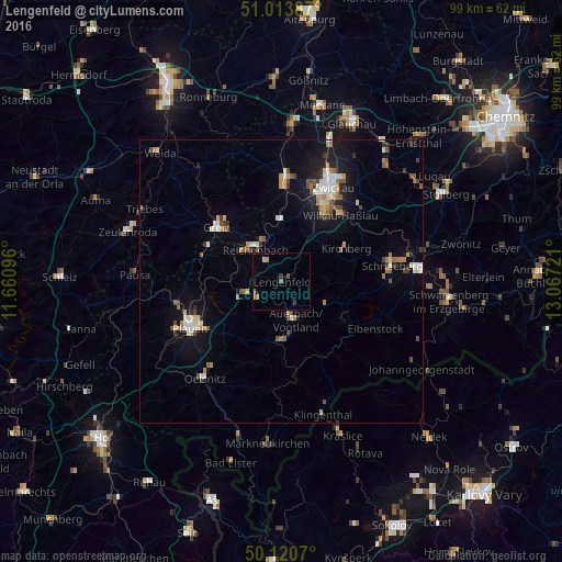
Analysis of Lengenfeld night lights 2016
Square area 10x10 km:
 0%
0%90-99
0%80-89
0.53%70-79
0.94%60-69
1.2%50-59
0.53%40-49
0.53%30-39
1.07%20-29
0%10-19
0%0-9
95.19%Square area 50x50 km:
0.6%90-99
0.73%80-89
0.59%70-79
0.71%60-69
0.62%50-59
0.74%40-49
0.62%30-39
0.52%20-29
0.61%10-19
3.77%0-9
90.49%Clear (daylight) street map image can be seen on geolist.org.
Map coordinates:
51° 0' 49.9" North, 11° 39' 39.5" East
50° 34' 9.8" North, 12° 21' 50.7" East
50° 7' 14.5" North, 13° 4' 2" East
Some cities around Lengenfeld sort by population:
• Reichenbach/Vogtland
7.3 km =4.5 mi,  324°
324°
• Auerbach
6.9 km =4.3 mi,  158°
158°
• Falkenstein
10.2 km =6.3 mi,  177°
177°
• Kirchberg
12.7 km =7.9 mi,  62°
62°
• Treuen
5.2 km =3.2 mi,  235°
235°
• Rodewisch
5.5 km =3.4 mi,  140°
140°
• Lichtentanne
14.4 km =8.9 mi,  17°
17°
• Schönheide
13.3 km =8.3 mi,  122°
122°
2878852 (p: 8,141)
Sources (retrieved 2019-11-25):
» Earth at Night: Flat Maps 2012, 2016