Langenargen night lights from space
Night Light of Langenargen (Baden-Württemberg) from space (Germany) Src. Average luminocity for 10x10km area is 2.794% and for 50x50km: 8.4631%.
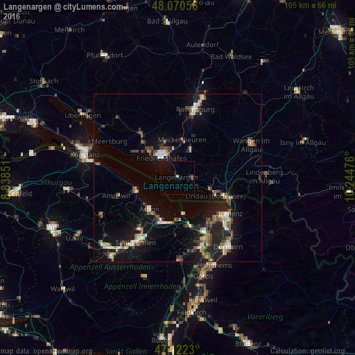
Analysis of Langenargen night lights 2016
Square area 10x10 km:
 0%
0%90-99
0%80-89
0.57%70-79
0%60-69
0%50-59
0%40-49
0.85%30-39
0.85%20-29
0.43%10-19
3.13%0-9
94.18%Square area 50x50 km:
0.69%90-99
1.17%80-89
0.82%70-79
0.79%60-69
1.17%50-59
1.26%40-49
1.55%30-39
1.28%20-29
2.15%10-19
8.17%0-9
80.95%Clear (daylight) street map image can be seen on geolist.org.
Map coordinates:
48° 4' 14" North, 8° 50' 18.6" East
47° 35' 54.9" North, 9° 32' 29.9" East
47° 7' 20.3" North, 10° 14' 41.1" East
Some cities around Langenargen sort by population:
• Friedrichshafen
8.2 km =5.1 mi,  322°
322°
• Lindau
12.2 km =7.6 mi,  118°
118°
• Tettnang
8.6 km =5.3 mi,  25°
25°
• Meckenbeuren
11.4 km =7.1 mi,  9°
9°
• Arbon, CH
12.2 km =7.6 mi,  221°
221°
• Rorschach, CH
13.9 km =8.6 mi,  196°
196°
• Romanshorn, CH
12.8 km =8 mi,  253°
253°
• Kressbronn am Bodensee
4.2 km =2.6 mi,  91°
91°
2881263 (p: 7,513)
Sources (retrieved 2019-11-25):
» Earth at Night: Flat Maps 2012, 2016