Kirn night lights from space
Night Light of Kirn (Rheinland-Pfalz) from space (Germany) Src. Average luminocity for 10x10km area is 1.3636% and for 50x50km: 1.8687%.
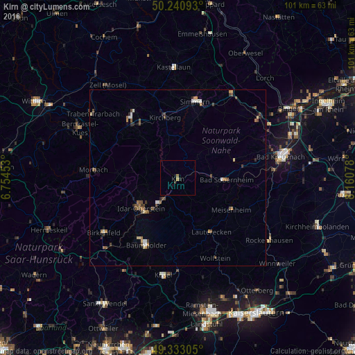
Analysis of Kirn night lights 2016
Square area 10x10 km:
 0%
0%90-99
0%80-89
0%70-79
0.53%60-69
0.4%50-59
0.13%40-49
0.27%30-39
0.27%20-29
0.53%10-19
0.67%0-9
97.19%Square area 50x50 km:
0.15%90-99
0.23%80-89
0.2%70-79
0.19%60-69
0.29%50-59
0.39%40-49
0.5%30-39
0.22%20-29
0.33%10-19
0.3%0-9
97.21%Clear (daylight) street map image can be seen on geolist.org.
Map coordinates:
50° 14' 27.3" North, 6° 45' 16.3" East
49° 47' 20.8" North, 7° 27' 27.5" East
49° 19' 59" North, 8° 9' 38.8" East
Some cities around Kirn sort by population:
• Bad Kreuznach
29.9 km =18.6 mi,  78°
78°
• Idar-Oberstein
13.6 km =8.5 mi,  232°
232°
• Morbach
23.8 km =14.8 mi,  274°
274°
• Freisen
30.5 km =19 mi,  209°
209°
• Simmern
22 km =13.7 mi,  12°
12°
• Birkenfeld
25.9 km =16.1 mi, 234°
• Traben-Trarbach
30.4 km =18.9 mi,  306°
306°
• Kusel
28.2 km =17.5 mi,  187°
187°
2890314 (p: 8,762)
Sources (retrieved 2019-11-25):
» Earth at Night: Flat Maps 2012, 2016