Traben-Trarbach night lights from space
Night Light of Traben-Trarbach (Rheinland-Pfalz) from space (Germany) Src. Average luminocity for 10x10km area is 3.1779% and for 50x50km: 1.3158%.
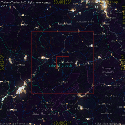
Analysis of Traben-Trarbach night lights 2016
Square area 10x10 km:
 0%
0%90-99
0%80-89
0.84%70-79
0.28%60-69
0.56%50-59
0.28%40-49
1.4%30-39
1.12%20-29
1.12%10-19
0.56%0-9
93.84%Square area 50x50 km:
0.11%90-99
0.14%80-89
0.07%70-79
0.16%60-69
0.19%50-59
0.27%40-49
0.32%30-39
0.29%20-29
0.3%10-19
0.34%0-9
97.8%Clear (daylight) street map image can be seen on geolist.org.
Map coordinates:
50° 24' 3.8" North, 6° 24' 45" East
49° 57' 2.7" North, 7° 6' 56.2" East
49° 29' 46.4" North, 7° 49' 7.5" East
Some cities around Traben-Trarbach sort by population:
• Idar-Oberstein
29.7 km =18.5 mi,  152°
152°
• Wittlich
16.4 km =10.2 mi,  283°
283°
• Morbach
15.9 km =9.9 mi,  177°
177°
• Simmern
29.4 km =18.3 mi,  83°
83°
• Bernkastel-Kues
4.8 km =3 mi,  215°
215°
• Schweich
29.7 km =18.5 mi,  241°
241°
• Kastellaun
26.8 km =16.7 mi,  60°
60°
• Cochem
21.9 km =13.6 mi,  9°
9°
2821690 (p: 6,018)
Sources (retrieved 2019-11-25):
» Earth at Night: Flat Maps 2012, 2016