Karlshorst night lights from space
Night Light of Karlshorst (Berlin) from space (Germany) Src. Average luminocity for 10x10km area is 88.7273% and for 50x50km: 34.9043%.
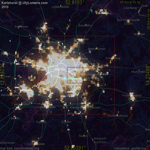

Analysis of Karlshorst night lights 2016
Square area 10x10 km:
 33.08%
90-99
30.18%80-89
12.75%70-79
12.5%60-69
4.92%50-59
3.28%40-49
2.27%30-39
1.01%20-29
0%10-19
0%0-9
0%Square area 50x50 km:
10.34%90-99
8.77%80-89
3.34%70-79
2.82%60-69
2.94%50-59
3.03%40-49
3.95%30-39
4.15%20-29
6.91%10-19
13.13%0-9
40.63%Clear (daylight) street map image can be seen on geolist.org.
Map coordinates:
52° 54' 37.1" North, 12° 49' 43.4" East
52° 29' 3.1" North, 13° 31' 54.7" East
52° 3' 14.1" North, 14° 14' 5.9" East
Some cities around Karlshorst sort by population:
• Friedrichsfelde
2.9 km =1.8 mi,  326°
326°
• Lichtenberg
4 km =2.5 mi, 326°
• Biesdorf
3.1 km =1.9 mi,  27°
27°
• Rummelsburg
3.2 km =2 mi,  306°
306°
• Oberschöneweide
2.7 km =1.7 mi,  195°
195°
• Baumschulenweg
3.8 km =2.4 mi,  237°
237°
• Plänterwald
4 km =2.5 mi,  265°
265°
• Niederschöneweide
3.4 km =2.1 mi, 199°
2892811 (p: 22,285)
Sources (retrieved 2019-11-25):
» Earth at Night: Flat Maps 2012, 2016