Baumschulenweg night lights from space
Night Light of Baumschulenweg (Berlin) from space (Germany) Src. Average luminocity for 10x10km area is 91.8788% and for 50x50km: 36.1242%.
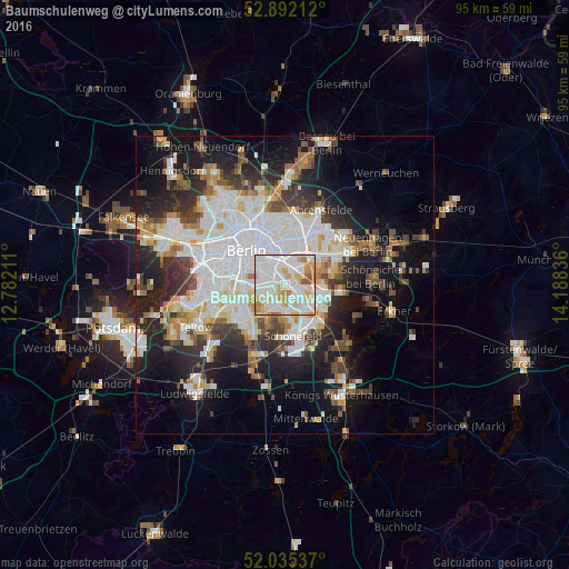
Analysis of Baumschulenweg night lights 2016
Square area 10x10 km:
 37.88%
90-99
31.31%80-89
14.52%70-79
9.97%60-69
3.91%50-59
2.4%40-49
0%30-39
0%20-29
0%10-19
0%0-9
0%Square area 50x50 km:
10.47%90-99
9%80-89
3.54%70-79
2.97%60-69
3.08%50-59
3.16%40-49
3.96%30-39
4.31%20-29
7.79%10-19
14.34%0-9
37.39%Clear (daylight) street map image can be seen on geolist.org.
Map coordinates:
52° 53' 31.6" North, 12° 46' 55.6" East
52° 27' 57" North, 13° 29' 6.8" East
52° 2' 7.3" North, 14° 11' 18.1" East
Some cities around Baumschulenweg sort by population:
• Neukölln
3.9 km =2.4 mi,  289°
289°
• Karlshorst
3.8 km =2.4 mi,  57°
57°
• Rummelsburg
4 km =2.5 mi,  7°
7°
• Oberschöneweide
2.5 km =1.6 mi,  102°
102°
• Johannisthal
2.6 km =1.6 mi,  145°
145°
• Alt-Treptow
3.1 km =1.9 mi,  324°
324°
• Plänterwald
1.9 km =1.2 mi,  333°
333°
• Niederschöneweide
2.3 km =1.4 mi,  118°
118°
2951935 (p: 17,186)
Sources (retrieved 2019-11-25):
» Earth at Night: Flat Maps 2012, 2016