Niederschöneweide night lights from space
Night Light of Niederschöneweide (Berlin) from space (Germany) Src. Average luminocity for 10x10km area is 88.6881% and for 50x50km: 34.9878%.
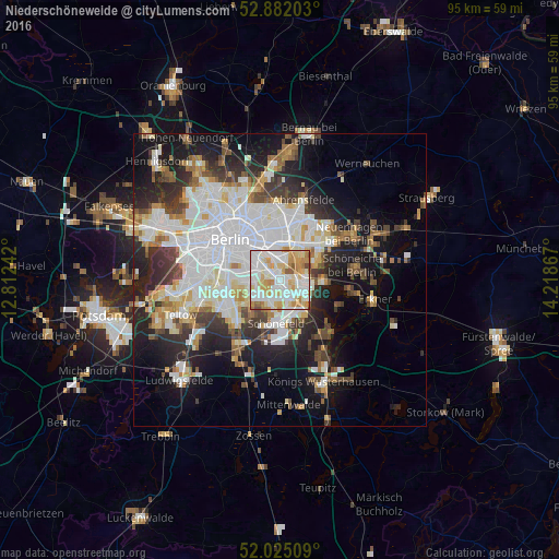
Analysis of Niederschöneweide night lights 2016
Square area 10x10 km:
 28.79%
90-99
31.19%80-89
15.4%70-79
13.51%60-69
5.93%50-59
3.79%40-49
1.39%30-39
0%20-29
0%10-19
0%0-9
0%Square area 50x50 km:
10.33%90-99
8.77%80-89
3.35%70-79
2.82%60-69
2.96%50-59
3.05%40-49
3.88%30-39
4.18%20-29
7.37%10-19
13.21%0-9
40.08%Clear (daylight) street map image can be seen on geolist.org.
Map coordinates:
52° 52' 55.3" North, 12° 48' 44.7" East
52° 27' 20.3" North, 13° 30' 55.9" East
52° 1' 30.3" North, 14° 13' 7.2" East
Some cities around Niederschöneweide sort by population:
• Köpenick
4.2 km =2.6 mi,  105°
105°
• Rudow
4.1 km =2.5 mi,  210°
210°
• Karlshorst
3.4 km =2.1 mi,  19°
19°
• Oberschöneweide
0.7 km =0.4 mi,  31°
31°
• Johannisthal
1.2 km =0.7 mi, 210°
• Baumschulenweg
2.3 km =1.4 mi,  298°
298°
• Adlershof
3.2 km =2 mi,  135°
135°
• Plänterwald
4 km =2.5 mi,  314°
314°
2862890 (p: 10,446)
Sources (retrieved 2019-11-25):
» Earth at Night: Flat Maps 2012, 2016