Holzwickede night lights from space
Night Light of Holzwickede (North Rhine-Westphalia) from space (Germany) Src. Average luminocity for 10x10km area is 32.2968% and for 50x50km: 23.7985%.
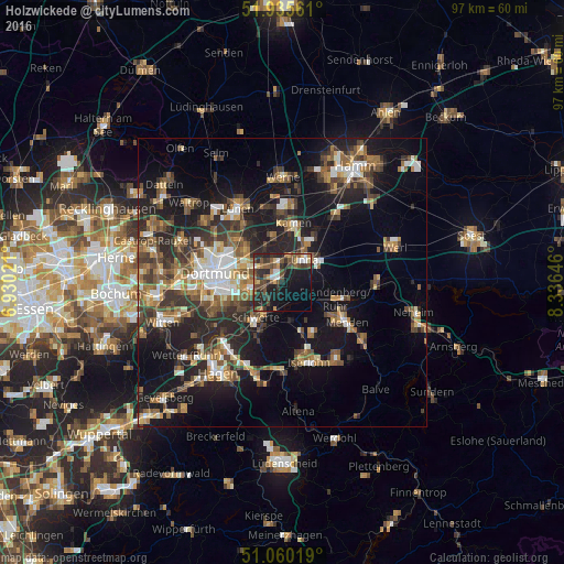
Analysis of Holzwickede night lights 2016
Square area 10x10 km:
 3.34%
3.34%90-99
2.54%80-89
2.27%70-79
3.48%60-69
4.14%50-59
8.02%40-49
9.63%30-39
5.88%20-29
16.04%10-19
23.93%0-9
20.72%Square area 50x50 km:
2.78%90-99
3.24%80-89
1.96%70-79
2.63%60-69
3.87%50-59
4.6%40-49
4.38%30-39
4.9%20-29
7.5%10-19
17.04%0-9
47.09%Clear (daylight) street map image can be seen on geolist.org.
Map coordinates:
51° 56' 8.2" North, 6° 55' 48.8" East
51° 30' 0" North, 7° 37' 60" East
51° 3' 36.7" North, 8° 20' 11.3" East
Some cities around Holzwickede sort by population:
• Dortmund
11.7 km =7.3 mi,  278°
278°
• Unna
5.7 km =3.5 mi,  42°
42°
• Menden
11.8 km =7.3 mi,  122°
122°
• Bergkamen
13 km =8.1 mi,  3°
3°
• Schwerte
7.7 km =4.8 mi,  216°
216°
• Kamen
10.5 km =6.5 mi,  11°
11°
• Fröndenberg
9.8 km =6.1 mi,  106°
106°
• Bönen
14.4 km =8.9 mi, 39°
2899538 (p: 17,821)
Sources (retrieved 2019-11-25):
» Earth at Night: Flat Maps 2012, 2016