Reinheim night lights from space
Night Light of Reinheim (Hesse) from space (Germany) Src. Average luminocity for 10x10km area is 1.4452% and for 50x50km: 14.1826%.
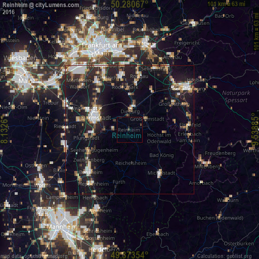
Analysis of Reinheim night lights 2016
Square area 10x10 km:
 0%
0%90-99
0%80-89
0%70-79
0%60-69
0%50-59
0.8%40-49
0.27%30-39
0%20-29
0.53%10-19
1.47%0-9
96.93%Square area 50x50 km:
2.13%90-99
2.24%80-89
1.15%70-79
1.41%60-69
1.74%50-59
1.46%40-49
1.69%30-39
1.69%20-29
5.03%10-19
15.67%0-9
65.8%Clear (daylight) street map image can be seen on geolist.org.
Map coordinates:
50° 16' 50.4" North, 8° 7' 57.4" East
49° 49' 45.2" North, 8° 50' 8.6" East
49° 22' 24.7" North, 9° 32' 19.9" East
Some cities around Reinheim sort by population:
• Groß-Umstadt
8.2 km =5.1 mi,  57°
57°
• Ober-Ramstadt
6.2 km =3.9 mi,  271°
271°
• Dieburg
7.6 km =4.7 mi,  5°
5°
• Münster
10.7 km =6.6 mi, 12°
• Groß-Zimmern
5 km =3.1 mi,  354°
354°
• Roßdorf
6.3 km =3.9 mi,  302°
302°
• Lützelbach
10.9 km =6.8 mi,  207°
207°
• Brensbach
7.1 km =4.4 mi,  150°
150°
2848762 (p: 17,841)
Sources (retrieved 2019-11-25):
» Earth at Night: Flat Maps 2012, 2016