Mömlingen night lights from space
Night Light of Mömlingen (Bavaria) from space (Germany) Src. Average luminocity for 10x10km area is 8.1297% and for 50x50km: 7.6302%.
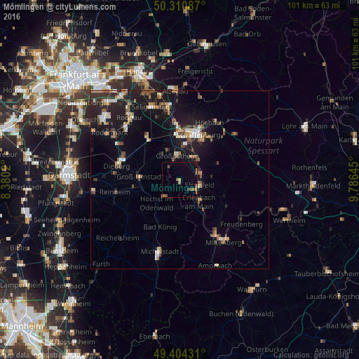
Analysis of Mömlingen night lights 2016
Square area 10x10 km:
 0%
0%90-99
0%80-89
1.6%70-79
2.41%60-69
1.34%50-59
1.07%40-49
2.14%30-39
0%20-29
0%10-19
0.4%0-9
91.04%Square area 50x50 km:
0.76%90-99
0.95%80-89
0.68%70-79
0.85%60-69
1.21%50-59
0.95%40-49
1.18%30-39
1.14%20-29
2.22%10-19
7.59%0-9
82.47%Clear (daylight) street map image can be seen on geolist.org.
Map coordinates:
50° 18' 39.1" North, 8° 22' 48.7" East
49° 51' 35" North, 9° 4' 60" East
49° 24' 15.5" North, 9° 47' 11.2" East
Some cities around Mömlingen sort by population:
• Großostheim
6.7 km =4.2 mi,  355°
355°
• Erlenbach am Main
8.5 km =5.3 mi,  137°
137°
• Höchst im Odenwald
9 km =5.6 mi,  222°
222°
• Obernburg am Main
4.3 km =2.7 mi,  127°
127°
• Schaafheim
8.9 km =5.5 mi,  323°
323°
• Elsenfeld
6 km =3.7 mi,  108°
108°
• Sulzbach am Main
7.6 km =4.7 mi,  40°
40°
• Kleinwallstadt
6.4 km =4 mi,  74°
74°
2869934 (p: 5,066)
Sources (retrieved 2019-11-25):
» Earth at Night: Flat Maps 2012, 2016