Elsenfeld night lights from space
Night Light of Elsenfeld (Bavaria) from space (Germany) Src. Average luminocity for 10x10km area is 9.5374% and for 50x50km: 5.9528%.
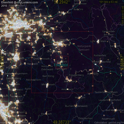
Analysis of Elsenfeld night lights 2016
Square area 10x10 km:
 0%
0%90-99
0.53%80-89
0.8%70-79
1.74%60-69
3.61%50-59
1.87%40-49
1.6%30-39
0.53%20-29
0.67%10-19
1.87%0-9
86.76%Square area 50x50 km:
0.56%90-99
0.68%80-89
0.5%70-79
0.63%60-69
1.13%50-59
0.78%40-49
0.99%30-39
0.62%20-29
1.28%10-19
6.09%0-9
86.73%Clear (daylight) street map image can be seen on geolist.org.
Map coordinates:
50° 17' 39.1" North, 8° 27' 37.5" East
49° 50' 34.4" North, 9° 9' 48.8" East
49° 23' 14.4" North, 9° 52' 0" East
Some cities around Elsenfeld sort by population:
• Großostheim
10.6 km =6.6 mi,  323°
323°
• Erlenbach am Main
4.4 km =2.7 mi,  180°
180°
• Höchst im Odenwald
12.7 km =7.9 mi,  247°
247°
• Obernburg am Main
2.5 km =1.6 mi, 251°
• Sulzbach am Main
7.7 km =4.8 mi,  354°
354°
• Klingenberg am Main
6.5 km =4 mi,  169°
169°
• Kleinwallstadt
3.6 km =2.2 mi,  6°
6°
• Mömlingen
6 km =3.7 mi,  288°
288°
2930747 (p: 8,727)
Sources (retrieved 2019-11-25):
» Earth at Night: Flat Maps 2012, 2016