Heroldsbach night lights from space
Night Light of Heroldsbach (Bavaria) from space (Germany) Src. Average luminocity for 10x10km area is 13.3102% and for 50x50km: 9.3938%.
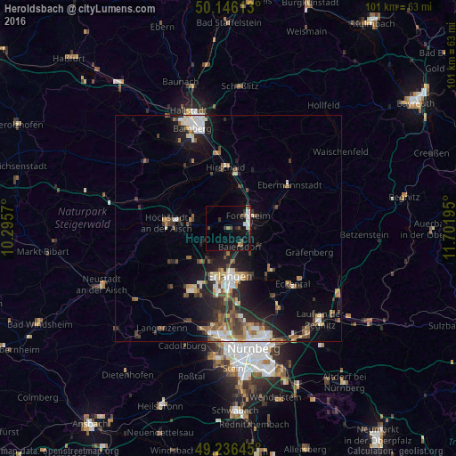
Analysis of Heroldsbach night lights 2016
Square area 10x10 km:
 1.6%
1.6%90-99
3.74%80-89
0%70-79
0.53%60-69
1.6%50-59
2.01%40-49
1.74%30-39
2.14%20-29
1.07%10-19
9.49%0-9
76.07%Square area 50x50 km:
1.38%90-99
1.53%80-89
0.92%70-79
0.83%60-69
1.1%50-59
1.34%40-49
1.57%30-39
1.34%20-29
3.16%10-19
6%0-9
80.84%Clear (daylight) street map image can be seen on geolist.org.
Map coordinates:
50° 8' 46.1" North, 10° 17' 44.5" East
49° 41' 36.3" North, 10° 59' 55.8" East
49° 14' 11.2" North, 11° 42' 7" East
Some cities around Heroldsbach sort by population:
• Erlangen
11.4 km =7.1 mi,  176°
176°
• Forchheim
5.1 km =3.2 mi,  58°
58°
• Höchstadt an der Aisch
13.4 km =8.3 mi,  276°
276°
• Hirschaid
13.9 km =8.6 mi,  357°
357°
• Neunkirchen am Brand
13.1 km =8.1 mi,  133°
133°
• Baiersdorf
4.8 km =3 mi,  145°
145°
• Eggolsheim
9.4 km =5.8 mi,  26°
26°
• Hemhofen
4.8 km =3 mi,  256°
256°
2905881 (p: 5,058)
Sources (retrieved 2019-11-25):
» Earth at Night: Flat Maps 2012, 2016