Hochheim am Main night lights from space
Night Light of Hochheim am Main (Hesse) from space (Germany) Src. Average luminocity for 10x10km area is 57.7255% and for 50x50km: 28.4579%.
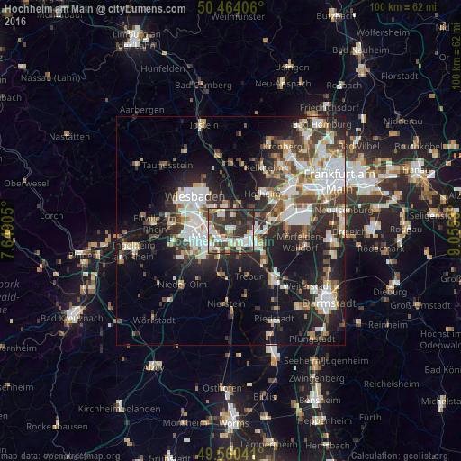
Analysis of Hochheim am Main night lights 2016
Square area 10x10 km:
 14.01%
90-99
14.43%80-89
5.6%70-79
5.04%60-69
3.78%50-59
4.62%40-49
10.36%30-39
14.99%20-29
23.39%10-19
3.78%0-9
0%Square area 50x50 km:
6.52%90-99
6.07%80-89
2.4%70-79
2.5%60-69
3.04%50-59
2.63%40-49
3.93%30-39
4.7%20-29
9.01%10-19
15.49%0-9
43.71%Clear (daylight) street map image can be seen on geolist.org.
Map coordinates:
50° 27' 50.6" North, 7° 38' 56.6" East
50° 0' 51.7" North, 8° 21' 7.8" East
49° 33' 37.5" North, 9° 3' 19.1" East
Some cities around Hochheim am Main sort by population:
• Mainz
6.2 km =3.9 mi,  237°
237°
• Rüsselsheim
5.7 km =3.5 mi,  118°
118°
• Flörsheim
5.4 km =3.4 mi,  91°
91°
• Ginsheim-Gustavsburg
4.8 km =3 mi,  185°
185°
• Raunheim
7.2 km =4.5 mi, 91°
• Trebur
10.5 km =6.5 mi,  158°
158°
• Bischofsheim
2.5 km =1.6 mi,  154°
154°
• Bodenheim
9.1 km =5.7 mi, 194°
2903175 (p: 17,027)
Sources (retrieved 2019-11-25):
» Earth at Night: Flat Maps 2012, 2016