Raunheim night lights from space
Night Light of Raunheim (Hesse) from space (Germany) Src. Average luminocity for 10x10km area is 48.951% and for 50x50km: 31.592%.
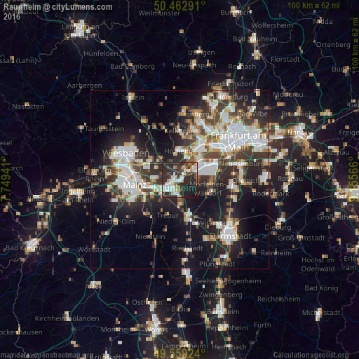
Analysis of Raunheim night lights 2016
Square area 10x10 km:
 10.64%
90-99
12.04%80-89
3.36%70-79
4.2%60-69
3.92%50-59
4.2%40-49
5.74%30-39
7.56%20-29
35.57%10-19
12.75%0-9
0%Square area 50x50 km:
7.37%90-99
6.8%80-89
2.65%70-79
2.81%60-69
3.23%50-59
2.84%40-49
4.17%30-39
5.58%20-29
10.4%10-19
16.56%0-9
37.59%Clear (daylight) street map image can be seen on geolist.org.
Map coordinates:
50° 27' 46.5" North, 7° 44' 57.9" East
50° 0' 47.5" North, 8° 27' 9.1" East
49° 33' 33.3" North, 9° 9' 20.4" East
Some cities around Raunheim sort by population:
• Rüsselsheim
3.4 km =2.1 mi,  219°
219°
• Hofheim am Taunus
8.6 km =5.3 mi,  358°
358°
• Hattersheim
7.4 km =4.6 mi,  12°
12°
• Flörsheim
1.8 km =1.1 mi,  269°
269°
• Hochheim am Main
7.2 km =4.5 mi, 271°
• Kelsterbach
7.7 km =4.8 mi,  45°
45°
• Bischofsheim
6.5 km =4 mi,  250°
250°
• Kriftel
8 km =5 mi, 8°
2849913 (p: 13,622)
Sources (retrieved 2019-11-25):
» Earth at Night: Flat Maps 2012, 2016