Trebur night lights from space
Night Light of Trebur (Hesse) from space (Germany) Src. Average luminocity for 10x10km area is 17.4524% and for 50x50km: 27.2135%.
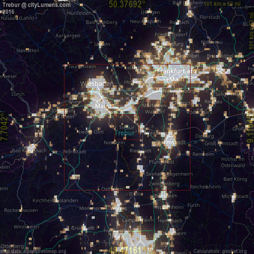
Analysis of Trebur night lights 2016
Square area 10x10 km:
 0%
0%90-99
0.98%80-89
1.26%70-79
2.38%60-69
2.38%50-59
1.82%40-49
3.22%30-39
0%20-29
12.61%10-19
34.31%0-9
41.04%Square area 50x50 km:
6.48%90-99
5.99%80-89
2.15%70-79
2.16%60-69
2.61%50-59
2.37%40-49
3.39%30-39
4.22%20-29
8.64%10-19
16.15%0-9
45.85%Clear (daylight) street map image can be seen on geolist.org.
Map coordinates:
50° 22' 36.9" North, 7° 42' 15.1" East
49° 55' 35" North, 8° 24' 26.4" East
49° 28' 17.8" North, 9° 6' 37.6" East
Some cities around Trebur sort by population:
• Rüsselsheim
7.1 km =4.4 mi,  8°
8°
• Groß-Gerau
5.4 km =3.4 mi,  95°
95°
• Ginsheim-Gustavsburg
6.7 km =4.2 mi,  318°
318°
• Büttelborn
8.7 km =5.4 mi,  107°
107°
• Bischofsheim
8 km =5 mi,  339°
339°
• Nierstein
8.1 km =5 mi,  218°
218°
• Bodenheim
6.3 km =3.9 mi,  278°
278°
• Nackenheim
5.1 km =3.2 mi,  255°
255°
2821416 (p: 12,897)
Sources (retrieved 2019-11-25):
» Earth at Night: Flat Maps 2012, 2016