Ginsheim-Gustavsburg night lights from space
Night Light of Ginsheim-Gustavsburg (Hesse) from space (Germany) Src. Average luminocity for 10x10km area is 49.3669% and for 50x50km: 27.4535%.
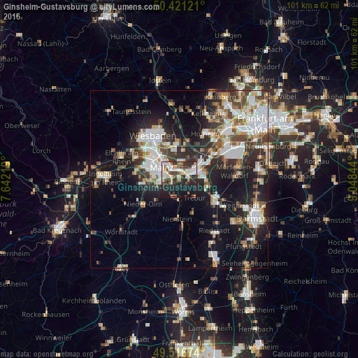
Analysis of Ginsheim-Gustavsburg night lights 2016
Square area 10x10 km:
 12.75%
90-99
11.48%80-89
4.34%70-79
3.78%60-69
4.9%50-59
3.64%40-49
6.02%30-39
6.86%20-29
22.55%10-19
22.13%0-9
1.54%Square area 50x50 km:
6.32%90-99
5.86%80-89
2.2%70-79
2.49%60-69
2.95%50-59
2.58%40-49
3.81%30-39
4.29%20-29
8.34%10-19
15.06%0-9
46.1%Clear (daylight) street map image can be seen on geolist.org.
Map coordinates:
50° 25' 16.4" North, 7° 38' 31.9" East
49° 58' 16" North, 8° 20' 43.2" East
49° 31' 0.3" North, 9° 2' 54.4" East
Some cities around Ginsheim-Gustavsburg sort by population:
• Mainz
5 km =3.1 mi,  287°
287°
• Rüsselsheim
5.9 km =3.7 mi,  69°
69°
• Flörsheim
7.5 km =4.7 mi,  51°
51°
• Hochheim am Main
4.8 km =3 mi,  5°
5°
• Trebur
6.7 km =4.2 mi,  138°
138°
• Bischofsheim
3 km =1.9 mi,  31°
31°
• Bodenheim
4.4 km =2.7 mi,  204°
204°
• Nackenheim
6.2 km =3.9 mi,  184°
184°
2920329 (p: 16,043)
Sources (retrieved 2019-11-25):
» Earth at Night: Flat Maps 2012, 2016