Lambsheim night lights from space
Night Light of Lambsheim (Rheinland-Pfalz) from space (Germany) Src. Average luminocity for 10x10km area is 21.8711% and for 50x50km: 21.0025%.
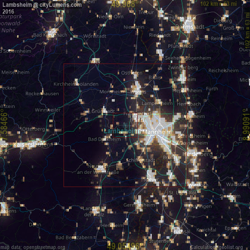
Analysis of Lambsheim night lights 2016
Square area 10x10 km:
 3.22%
3.22%90-99
4.06%80-89
0.14%70-79
2.66%60-69
3.5%50-59
0.98%40-49
3.22%30-39
3.08%20-29
10.5%10-19
18.35%0-9
50.28%Square area 50x50 km:
4.08%90-99
4.54%80-89
1.76%70-79
1.5%60-69
2.09%50-59
2.09%40-49
2.58%30-39
3.03%20-29
7.32%10-19
14.85%0-9
56.15%Clear (daylight) street map image can be seen on geolist.org.
Map coordinates:
49° 58' 4.8" North, 7° 35' 4.8" East
49° 30' 49" North, 8° 17' 16" East
49° 3' 17.9" North, 8° 59' 27.3" East
Some cities around Lambsheim sort by population:
• Frankenthal
5.3 km =3.3 mi,  64°
64°
• Bad Dürkheim
10.1 km =6.3 mi,  235°
235°
• Mutterstadt
9.4 km =5.8 mi,  148°
148°
• Herxheim am Berg
7.9 km =4.9 mi,  266°
266°
• Bobenheim-Roxheim
9.6 km =6 mi,  31°
31°
• Dannstadt-Schauernheim
8.3 km =5.2 mi,  169°
169°
• Heidesheim
10.2 km =6.3 mi,  318°
318°
• Maxdorf
2.9 km =1.8 mi, 174°
2881767 (p: 6,104)
Sources (retrieved 2019-11-25):
» Earth at Night: Flat Maps 2012, 2016