Hansaviertel night lights from space
Night Light of Hansaviertel (Berlin) from space (Germany) Src. Average luminocity for 10x10km area is 97.9392% and for 50x50km: 38.5276%.
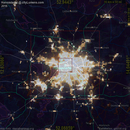
Analysis of Hansaviertel night lights 2016
Square area 10x10 km:
 68.65%
90-99
25.79%80-89
1.72%70-79
1.98%60-69
1.32%50-59
0.26%40-49
0.26%30-39
0%20-29
0%10-19
0%0-9
0%Square area 50x50 km:
11.1%90-99
9.59%80-89
3.7%70-79
2.99%60-69
3.36%50-59
3.52%40-49
4.01%30-39
4.43%20-29
8.84%10-19
16.06%0-9
32.38%Clear (daylight) street map image can be seen on geolist.org.
Map coordinates:
52° 56' 39.5" North, 12° 38' 19.2" East
52° 31' 6.7" North, 13° 20' 30.4" East
52° 5' 18.9" North, 14° 2' 41.7" East
Some cities around Hansaviertel sort by population:
• Charlottenburg
4 km =2.5 mi,  267°
267°
• Wilmersdorf
4.3 km =2.7 mi,  203°
203°
• Mitte
4.3 km =2.7 mi,  87°
87°
• Wedding
3.3 km =2.1 mi,  16°
16°
• Moabit
0.9 km =0.6 mi,  347°
347°
• Charlottenburg-Nord
3.5 km =2.2 mi,  292°
292°
• Halensee
4.4 km =2.7 mi,  224°
224°
• Tiergarten
1.7 km =1.1 mi,  97°
97°
8334620 (p: 5,629)
Sources (retrieved 2019-11-25):
» Earth at Night: Flat Maps 2012, 2016