Charlottenburg-Nord night lights from space
Night Light of Charlottenburg-Nord (Berlin) from space (Germany) Src. Average luminocity for 10x10km area is 89.4749% and for 50x50km: 37.9402%.
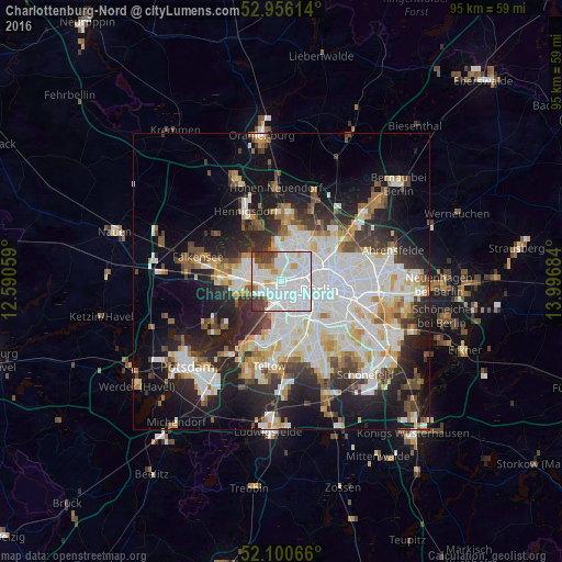
Analysis of Charlottenburg-Nord night lights 2016
Square area 10x10 km:
 52.12%
90-99
25.66%80-89
2.91%70-79
2.91%60-69
3.57%50-59
1.59%40-49
6.48%30-39
4.76%20-29
0%10-19
0%0-9
0%Square area 50x50 km:
11.04%90-99
9.53%80-89
3.7%70-79
2.99%60-69
3.26%50-59
3.42%40-49
3.78%30-39
4.25%20-29
8.74%10-19
15.01%0-9
34.29%Clear (daylight) street map image can be seen on geolist.org.
Map coordinates:
52° 57' 22.1" North, 12° 35' 26.1" East
52° 31' 49.7" North, 13° 17' 37.4" East
52° 6' 2.4" North, 13° 59' 48.6" East
Some cities around Charlottenburg-Nord sort by population:
• Wedding
4.6 km =2.9 mi,  65°
65°
• Reinickendorf
4.8 km =3 mi,  33°
33°
• Moabit
3.1 km =1.9 mi,  98°
98°
• Westend
1.9 km =1.2 mi,  218°
218°
• Haselhorst
4.1 km =2.5 mi,  291°
291°
• Halensee
4.5 km =2.8 mi,  178°
178°
• Siemensstadt
2.4 km =1.5 mi,  298°
298°
• Hansaviertel
3.5 km =2.2 mi,  112°
112°
6545288 (p: 17,942)
Sources (retrieved 2019-11-25):
» Earth at Night: Flat Maps 2012, 2016