Hückeswagen night lights from space
Night Light of Hückeswagen (North Rhine-Westphalia) from space (Germany) Src. Average luminocity for 10x10km area is 4.7299% and for 50x50km: 18.0682%.
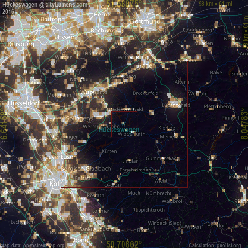
Analysis of Hückeswagen night lights 2016
Square area 10x10 km:
 0%
0%90-99
0.53%80-89
0.53%70-79
0.53%60-69
0%50-59
0.94%40-49
0.8%30-39
0.8%20-29
1.74%10-19
2.27%0-9
91.84%Square area 50x50 km:
2.01%90-99
2.47%80-89
1.71%70-79
2.66%60-69
2.72%50-59
2.86%40-49
2.89%30-39
2.74%20-29
6.92%10-19
13.87%0-9
59.15%Clear (daylight) street map image can be seen on geolist.org.
Map coordinates:
51° 35' 19.5" North, 6° 38' 29.7" East
51° 8' 59.2" North, 7° 20' 41" East
50° 42' 23.8" North, 8° 2' 52.2" East
Some cities around Hückeswagen sort by population:
• Remscheid
11.1 km =6.9 mi,  287°
287°
• Wermelskirchen
9.1 km =5.7 mi,  262°
262°
• Radevormwald
5.9 km =3.7 mi,  10°
10°
• Wipperfürth
5.3 km =3.3 mi,  134°
134°
• Lindlar
14.7 km =9.1 mi,  170°
170°
• Kürten
12.4 km =7.7 mi,  206°
206°
• Halver
11.4 km =7.1 mi,  69°
69°
• Breckerfeld
14.9 km =9.3 mi,  35°
35°
2898098 (p: 16,369)
Sources (retrieved 2019-11-25):
» Earth at Night: Flat Maps 2012, 2016