Großostheim night lights from space
Night Light of Großostheim (Bavaria) from space (Germany) Src. Average luminocity for 10x10km area is 14.1092% and for 50x50km: 10.8925%.
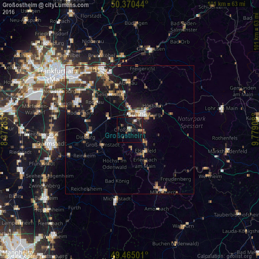
Analysis of Großostheim night lights 2016
Square area 10x10 km:
 0.84%
0.84%90-99
1.26%80-89
0.14%70-79
0.56%60-69
2.38%50-59
1.82%40-49
3.22%30-39
0.98%20-29
7.42%10-19
23.11%0-9
58.26%Square area 50x50 km:
1.51%90-99
1.84%80-89
0.94%70-79
1.11%60-69
1.7%50-59
1.27%40-49
1.4%30-39
1.71%20-29
3.38%10-19
8.64%0-9
76.5%Clear (daylight) street map image can be seen on geolist.org.
Map coordinates:
50° 22' 13.6" North, 8° 22' 22.2" East
49° 55' 11.5" North, 9° 4' 33.5" East
49° 27' 54" North, 9° 46' 44.7" East
Some cities around Großostheim sort by population:
• Aschaffenburg
8.4 km =5.2 mi,  40°
40°
• Schaafheim
4.8 km =3 mi,  275°
275°
• Kleinostheim
8.9 km =5.5 mi,  355°
355°
• Mainaschaff
6.9 km =4.3 mi,  8°
8°
• Stockstadt am Main
5.6 km =3.5 mi, 356°
• Sulzbach am Main
5.6 km =3.5 mi,  99°
99°
• Kleinwallstadt
8.4 km =5.2 mi,  126°
126°
• Mömlingen
6.7 km =4.2 mi,  175°
175°
2915196 (p: 16,346)
Sources (retrieved 2019-11-25):
» Earth at Night: Flat Maps 2012, 2016