Kleinostheim night lights from space
Night Light of Kleinostheim (Bavaria) from space (Germany) Src. Average luminocity for 10x10km area is 25.3333% and for 50x50km: 13.12%.
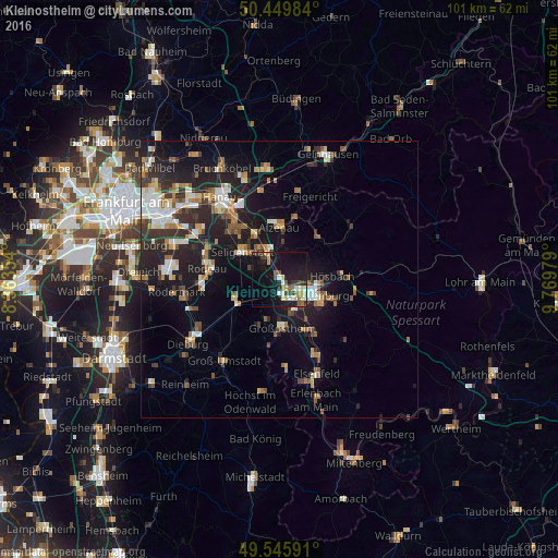
Analysis of Kleinostheim night lights 2016
Square area 10x10 km:
 3.08%
3.08%90-99
4.06%80-89
3.36%70-79
2.1%60-69
3.08%50-59
2.1%40-49
3.64%30-39
3.22%20-29
5.74%10-19
37.39%0-9
32.21%Square area 50x50 km:
1.68%90-99
2.13%80-89
1.17%70-79
1.37%60-69
2.04%50-59
1.52%40-49
1.58%30-39
2.14%20-29
4.65%10-19
10.98%0-9
70.75%Clear (daylight) street map image can be seen on geolist.org.
Map coordinates:
50° 26' 59.4" North, 8° 21' 48.7" East
50° 0' 0" North, 9° 4' 0" East
49° 32' 45.3" North, 9° 46' 11.2" East
Some cities around Kleinostheim sort by population:
• Aschaffenburg
6.6 km =4.1 mi,  112°
112°
• Seligenstadt
8.2 km =5.1 mi,  305°
305°
• Babenhausen
9.1 km =5.7 mi,  244°
244°
• Großostheim
8.9 km =5.5 mi,  175°
175°
• Goldbach
8.4 km =5.2 mi,  90°
90°
• Mainaschaff
2.6 km =1.6 mi,  140°
140°
• Stockstadt am Main
3.3 km =2.1 mi,  174°
174°
• Kahl am Main
8.9 km =5.5 mi,  330°
330°
2888411 (p: 8,409)
Sources (retrieved 2019-11-25):
» Earth at Night: Flat Maps 2012, 2016