Grimma night lights from space
Night Light of Grimma (Saxony) from space (Germany) Src. Average luminocity for 10x10km area is 3.3852% and for 50x50km: 5.8098%.
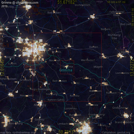
Analysis of Grimma night lights 2016
Square area 10x10 km:
 0%
0%90-99
0%80-89
1.68%70-79
0.56%60-69
0%50-59
0.56%40-49
1.12%30-39
0.56%20-29
0%10-19
0%0-9
95.52%Square area 50x50 km:
0.9%90-99
1.17%80-89
0.65%70-79
0.59%60-69
0.78%50-59
0.88%40-49
0.89%30-39
0.85%20-29
1.05%10-19
2.53%0-9
89.7%Clear (daylight) street map image can be seen on geolist.org.
Map coordinates:
51° 40' 18.6" North, 12° 0' 59.3" East
51° 14' 1.2" North, 12° 43' 10.5" East
50° 47' 28.7" North, 13° 25' 21.8" East
Some cities around Grimma sort by population:
• Wurzen
15.3 km =9.5 mi,  5°
5°
• Brandis
13.7 km =8.5 mi,  326°
326°
• Bad Lausick
11.2 km =7 mi,  207°
207°
• Naunhof
10.4 km =6.5 mi,  298°
298°
• Kitzscher
14 km =8.7 mi,  236°
236°
• Großpösna
15.7 km =9.8 mi,  283°
283°
• Bennewitz
14.1 km =8.8 mi,  358°
358°
• Colditz
13.1 km =8.1 mi,  153°
153°
2917325 (p: 17,991)
Sources (retrieved 2019-11-25):
» Earth at Night: Flat Maps 2012, 2016