Brandis night lights from space
Night Light of Brandis (Saxony) from space (Germany) Src. Average luminocity for 10x10km area is 2.6246% and for 50x50km: 9.5767%.
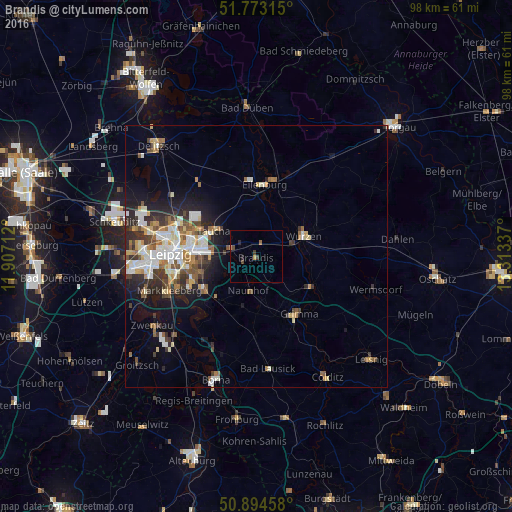
Analysis of Brandis night lights 2016
Square area 10x10 km:
 0%
0%90-99
0%80-89
0%70-79
0.7%60-69
0.7%50-59
0%40-49
1.26%30-39
0.98%20-29
1.12%10-19
0%0-9
95.24%Square area 50x50 km:
1.73%90-99
2.04%80-89
1.01%70-79
0.97%60-69
1.2%50-59
1.16%40-49
1.15%30-39
1.65%20-29
2.3%10-19
4.1%0-9
82.68%Clear (daylight) street map image can be seen on geolist.org.
Map coordinates:
51° 46' 23.3" North, 11° 54' 25.6" East
51° 20' 9.5" North, 12° 36' 36.9" East
50° 53' 40.5" North, 13° 18' 48.1" East
Some cities around Brandis sort by population:
• Grimma
13.7 km =8.5 mi,  146°
146°
• Wurzen
9.8 km =6.1 mi,  66°
66°
• Taucha
10.3 km =6.4 mi,  300°
300°
• Naunhof
6.7 km =4.2 mi,  193°
193°
• Borsdorf
5.6 km =3.5 mi,  286°
286°
• Machern
3.8 km =2.4 mi,  25°
25°
• Großpösna
10.9 km =6.8 mi,  224°
224°
• Bennewitz
7.7 km =4.8 mi, 69°
2945270 (p: 9,728)
Sources (retrieved 2019-11-25):
» Earth at Night: Flat Maps 2012, 2016