Großpösna night lights from space
Night Light of Großpösna (Saxony) from space (Germany) Src. Average luminocity for 10x10km area is 9.423% and for 50x50km: 11.1243%.
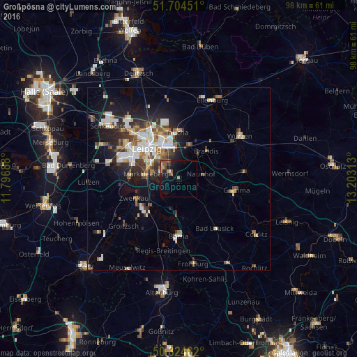
Analysis of Großpösna night lights 2016
Square area 10x10 km:
 0.28%
0.28%90-99
0.84%80-89
0.7%70-79
1.82%60-69
1.4%50-59
2.52%40-49
1.12%30-39
1.12%20-29
1.96%10-19
10.08%0-9
78.15%Square area 50x50 km:
2%90-99
2.39%80-89
1.08%70-79
1.02%60-69
1.3%50-59
1.31%40-49
1.32%30-39
1.84%20-29
2.83%10-19
5.9%0-9
79.02%Clear (daylight) street map image can be seen on geolist.org.
Map coordinates:
51° 42' 16.2" North, 11° 47' 48.8" East
51° 16' 0" North, 12° 30' 0" East
50° 49' 28.6" North, 13° 12' 11.3" East
Some cities around Großpösna sort by population:
• Leipzig
12.1 km =7.5 mi,  312°
312°
• Markkleeberg
9.2 km =5.7 mi,  276°
276°
• Brandis
10.9 km =6.8 mi,  44°
44°
• Zwenkau
13 km =8.1 mi,  245°
245°
• Naunhof
6.3 km =3.9 mi,  78°
78°
• Borsdorf
9.6 km =6 mi,  14°
14°
• Böhlen
10.8 km =6.7 mi,  227°
227°
• Kitzscher
11.9 km =7.4 mi,  162°
162°
2915173 (p: 5,608)
Sources (retrieved 2019-11-25):
» Earth at Night: Flat Maps 2012, 2016