Geiselhöring night lights from space
Night Light of Geiselhöring (Bavaria) from space (Germany) Src. Average luminocity for 10x10km area is 1.3991% and for 50x50km: 5.3004%.
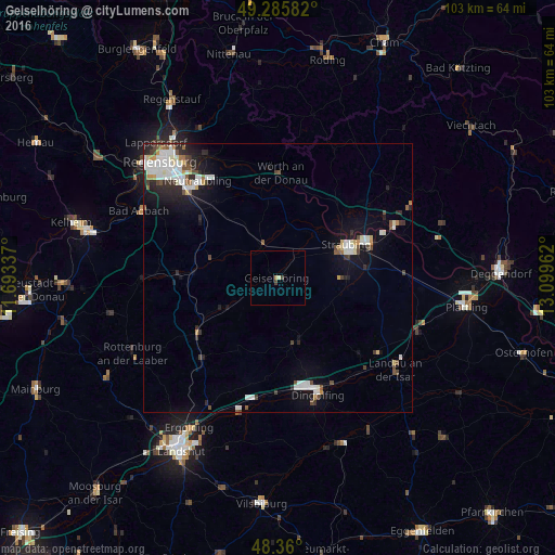
Analysis of Geiselhöring night lights 2016
Square area 10x10 km:
 0%
0%90-99
0%80-89
0.57%70-79
0%60-69
0.57%50-59
0%40-49
0.71%30-39
0.43%20-29
0%10-19
0%0-9
97.73%Square area 50x50 km:
1.11%90-99
1.34%80-89
0.38%70-79
0.3%60-69
0.33%50-59
0.41%40-49
0.79%30-39
0.57%20-29
1.37%10-19
3.1%0-9
90.31%Clear (daylight) street map image can be seen on geolist.org.
Map coordinates:
49° 17' 9" North, 11° 41' 36.1" East
48° 49' 30.2" North, 12° 23' 47.4" East
48° 21' 36" North, 13° 5' 58.6" East
Some cities around Geiselhöring sort by population:
• Straubing
14.4 km =8.9 mi,  64°
64°
• Dingolfing
21.5 km =13.4 mi,  160°
160°
• Neutraubling
23 km =14.3 mi,  321°
321°
• Ergoldsbach
20.4 km =12.7 mi,  223°
223°
• Schierling
18.8 km =11.7 mi,  273°
273°
• Obertraubling
23 km =14.3 mi,  313°
313°
• Mallersdorf-Pfaffenberg
13.8 km =8.6 mi,  241°
241°
• Mengkofen
12.2 km =7.6 mi, 164°
2921736 (p: 6,872)
Sources (retrieved 2019-11-25):
» Earth at Night: Flat Maps 2012, 2016