Ergoldsbach night lights from space
Night Light of Ergoldsbach (Bavaria) from space (Germany) Src. Average luminocity for 10x10km area is 0.9702% and for 50x50km: 3.4285%.
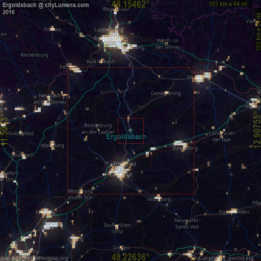
Analysis of Ergoldsbach night lights 2016
Square area 10x10 km:
 0%
0%90-99
0%80-89
0%70-79
0.3%60-69
0%50-59
0%40-49
0.15%30-39
1.04%20-29
0.89%10-19
0%0-9
97.62%Square area 50x50 km:
0.51%90-99
0.71%80-89
0.23%70-79
0.31%60-69
0.3%50-59
0.37%40-49
0.41%30-39
0.4%20-29
0.77%10-19
2.34%0-9
93.65%Clear (daylight) street map image can be seen on geolist.org.
Map coordinates:
49° 9' 16.6" North, 11° 30' 4.7" East
48° 41' 33.5" North, 12° 12' 15.9" East
48° 13' 34.9" North, 12° 54' 27.2" East
Some cities around Ergoldsbach sort by population:
• Landshut
18.4 km =11.4 mi,  189°
189°
• Essenbach
8.9 km =5.5 mi,  173°
173°
• Rottenburg an der Laaber
13.1 km =8.1 mi,  274°
274°
• Schierling
16.4 km =10.2 mi,  343°
343°
• Geiselhöring
20.4 km =12.7 mi,  43°
43°
• Mallersdorf-Pfaffenberg
8.4 km =5.2 mi,  13°
13°
• Mengkofen
17.6 km =10.9 mi,  80°
80°
• Langquaid
18.3 km =11.4 mi,  322°
322°
2929649 (p: 7,482)
Sources (retrieved 2019-11-25):
» Earth at Night: Flat Maps 2012, 2016