Freilassing night lights from space
Night Light of Freilassing (Bavaria) from space (Germany) Src. Average luminocity for 10x10km area is 38.6503% and for 50x50km: 4.9652%.
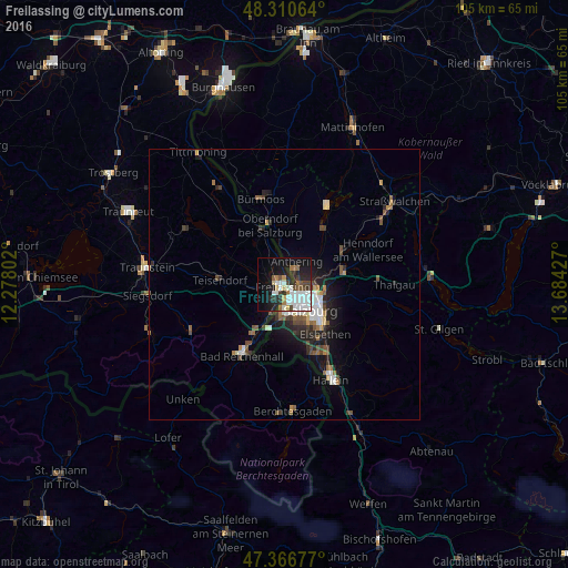
Analysis of Freilassing night lights 2016
Square area 10x10 km:
 11.31%
90-99
10.12%80-89
2.23%70-79
1.34%60-69
4.61%50-59
2.08%40-49
4.61%30-39
4.61%20-29
11.31%10-19
21.58%0-9
26.19%Square area 50x50 km:
0.89%90-99
0.92%80-89
0.26%70-79
0.32%60-69
0.59%50-59
0.74%40-49
0.86%30-39
0.57%20-29
1.64%10-19
3.17%0-9
90.04%Clear (daylight) street map image can be seen on geolist.org.
Map coordinates:
48° 18' 38.3" North, 12° 16' 40.9" East
47° 50' 27.1" North, 12° 58' 52.1" East
47° 22' 0.4" North, 13° 41' 3.4" East
Some cities around Freilassing sort by population:
• Salzburg, AT
6.6 km =4.1 mi,  134°
134°
• Bad Reichenhall
14.6 km =9.1 mi,  211°
211°
• Ainring
4.3 km =2.7 mi,  224°
224°
• Teisendorf
12.1 km =7.5 mi,  274°
274°
• Hallein, AT
19.6 km =12.2 mi,  153°
153°
• Laufen
11.2 km =7 mi,  339°
339°
• Oberndorf bei Salzburg, AT
12.6 km =7.8 mi, 343°
• Piding
9.6 km =6 mi, 210°
2925080 (p: 15,909)
Sources (retrieved 2019-11-25):
» Earth at Night: Flat Maps 2012, 2016