Oberndorf bei Salzburg night lights from space
Night Light of Oberndorf bei Salzburg (Salzburg) from space (Austria) Src. Average luminocity for 10x10km area is 2.3722% and for 50x50km: 5.4273%.
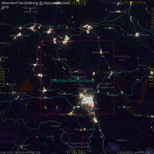
Analysis of Oberndorf bei Salzburg night lights 2016
Square area 10x10 km:
 0%
0%90-99
0%80-89
0%70-79
0.57%60-69
0%50-59
0.99%40-49
0.14%30-39
1.14%20-29
1.56%10-19
1.7%0-9
93.89%Square area 50x50 km:
0.92%90-99
0.99%80-89
0.37%70-79
0.5%60-69
0.67%50-59
0.76%40-49
0.79%30-39
0.59%20-29
1.72%10-19
3.28%0-9
89.4%Clear (daylight) street map image can be seen on geolist.org.
Map coordinates:
48° 25' 7.6" North, 12° 13' 48.8" East
47° 57' 0" North, 12° 55' 60" East
47° 28' 36.9" North, 13° 38' 11.3" East
Some cities around Oberndorf bei Salzburg sort by population:
• Salzburg
18.7 km =11.6 mi,  153°
153°
• Freilassing, DE
12.6 km =7.8 mi,  163°
163°
• Ainring, DE
15.2 km =9.4 mi,  177°
177°
• Teisendorf, DE
14.1 km =8.8 mi,  217°
217°
• Laufen, DE
1.6 km =1 mi,  192°
192°
• Waging am See, DE
15 km =9.3 mi,  263°
263°
• Tittmoning, DE
17.5 km =10.9 mi,  315°
315°
• Piding, DE
20.4 km =12.7 mi, 183°
2769874 (p: 5,794)
Sources (retrieved 2019-11-25):
» Earth at Night: Flat Maps 2012, 2016