Asperg night lights from space
Night Light of Asperg (Baden-Württemberg) from space (Germany) Src. Average luminocity for 10x10km area is 58.5682% and for 50x50km: 26.3223%.
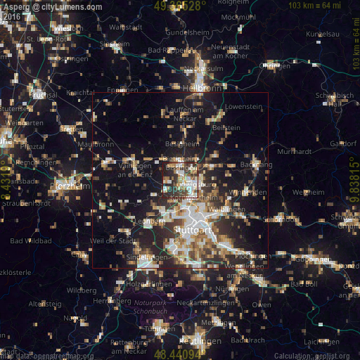
Analysis of Asperg night lights 2016
Square area 10x10 km:
 11.22%
90-99
17.05%80-89
4.12%70-79
6.39%60-69
9.8%50-59
4.83%40-49
7.39%30-39
13.21%20-29
19.74%10-19
6.25%0-9
0%Square area 50x50 km:
4.36%90-99
4.95%80-89
2.22%70-79
2.88%60-69
3.56%50-59
3.35%40-49
3.83%30-39
4.17%20-29
8.17%10-19
15.61%0-9
46.9%Clear (daylight) street map image can be seen on geolist.org.
Map coordinates:
49° 21' 55" North, 8° 25' 54.8" East
48° 54' 18.9" North, 9° 8' 6.1" East
48° 26' 27.4" North, 9° 50' 17.3" East
Some cities around Asperg sort by population:
• Ludwigsburg
4.2 km =2.6 mi,  102°
102°
• Bietigheim-Bissingen
4.5 km =2.8 mi,  343°
343°
• Kornwestheim
6.1 km =3.8 mi,  142°
142°
• Freiberg am Neckar
5.7 km =3.5 mi,  58°
58°
• Markgröningen
4 km =2.5 mi,  269°
269°
• Tamm
2.2 km =1.4 mi,  318°
318°
• Schwieberdingen
5.5 km =3.4 mi,  234°
234°
• Möglingen
2.1 km =1.3 mi,  196°
196°
2955068 (p: 12,870)
Sources (retrieved 2019-11-25):
» Earth at Night: Flat Maps 2012, 2016