Essenbach night lights from space
Night Light of Essenbach (Bavaria) from space (Germany) Src. Average luminocity for 10x10km area is 5.6057% and for 50x50km: 3.3568%.
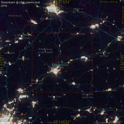
Analysis of Essenbach night lights 2016
Square area 10x10 km:
 0%
0%90-99
0.3%80-89
0.89%70-79
0.6%60-69
1.19%50-59
0.6%40-49
0.6%30-39
0%20-29
1.79%10-19
7.44%0-9
86.61%Square area 50x50 km:
0.5%90-99
0.68%80-89
0.21%70-79
0.32%60-69
0.32%50-59
0.3%40-49
0.46%30-39
0.47%20-29
0.83%10-19
2.34%0-9
93.57%Clear (daylight) street map image can be seen on geolist.org.
Map coordinates:
49° 4' 33.7" North, 11° 30' 54.8" East
48° 36' 48" North, 12° 13' 6" East
48° 8' 46.8" North, 12° 55' 17.3" East
Some cities around Essenbach sort by population:
• Landshut
10.2 km =6.3 mi,  204°
204°
• Ergolding
5.4 km =3.4 mi,  220°
220°
• Rottenburg an der Laaber
17.2 km =10.7 mi,  305°
305°
• Ergoldsbach
8.9 km =5.5 mi,  353°
353°
• Mallersdorf-Pfaffenberg
17 km =10.6 mi,  3°
3°
• Geisenhausen
15.5 km =9.6 mi,  169°
169°
• Mengkofen
20.1 km =12.5 mi,  54°
54°
• Bruckberg
19.3 km =12 mi,  238°
238°
2928804 (p: 11,070)
Sources (retrieved 2019-11-25):
» Earth at Night: Flat Maps 2012, 2016