Erbach night lights from space
Night Light of Erbach (Baden-Württemberg) from space (Germany) Src. Average luminocity for 10x10km area is 9.5994% and for 50x50km: 6.2254%.
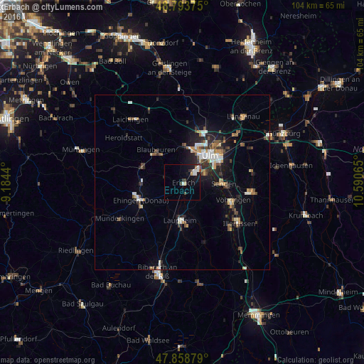
Analysis of Erbach night lights 2016
Square area 10x10 km:
 2.13%
2.13%90-99
1.85%80-89
0.57%70-79
0.57%60-69
0.57%50-59
0%40-49
1.56%30-39
1.85%20-29
0.71%10-19
9.52%0-9
80.68%Square area 50x50 km:
0.86%90-99
0.95%80-89
0.5%70-79
0.7%60-69
0.65%50-59
0.75%40-49
1.02%30-39
0.97%20-29
1.66%10-19
3.82%0-9
88.12%Clear (daylight) street map image can be seen on geolist.org.
Map coordinates:
48° 47' 37.5" North, 9° 11' 3.8" East
48° 19' 42.3" North, 9° 53' 15.1" East
47° 51' 31.6" North, 10° 35' 26.3" East
Some cities around Erbach sort by population:
• Ulm
10.9 km =6.8 mi,  44°
44°
• Neu-Ulm
11.6 km =7.2 mi,  51°
51°
• Ehingen
12.9 km =8 mi,  246°
246°
• Senden
11.6 km =7.2 mi,  92°
92°
• Laupheim
11.2 km =7 mi,  183°
183°
• Klingenstein
10.1 km =6.3 mi,  8°
8°
• Blaubeuren
12 km =7.5 mi,  320°
320°
• Schelklingen
12.6 km =7.8 mi,  294°
294°
2929804 (p: 13,331)
Sources (retrieved 2019-11-25):
» Earth at Night: Flat Maps 2012, 2016