Laupheim night lights from space
Night Light of Laupheim (Baden-Württemberg) from space (Germany) Src. Average luminocity for 10x10km area is 7.1741% and for 50x50km: 6.0792%.
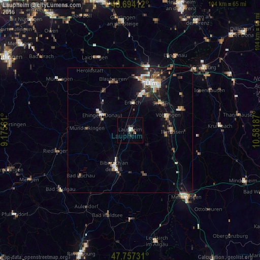
Analysis of Laupheim night lights 2016
Square area 10x10 km:
 0.74%
0.74%90-99
2.23%80-89
0%70-79
0.6%60-69
0.6%50-59
1.19%40-49
0.74%30-39
1.04%20-29
1.19%10-19
2.53%0-9
89.14%Square area 50x50 km:
0.92%90-99
0.9%80-89
0.5%70-79
0.59%60-69
0.68%50-59
0.69%40-49
1.03%30-39
0.97%20-29
1.59%10-19
3.64%0-9
88.5%Clear (daylight) street map image can be seen on geolist.org.
Map coordinates:
48° 41' 38.8" North, 9° 10' 32.2" East
48° 13' 40.3" North, 9° 52' 43.5" East
47° 45' 26.3" North, 10° 34' 54.7" East
Some cities around Laupheim sort by population:
• Biberach an der Riß
16.3 km =10.1 mi,  203°
203°
• Ehingen
12.7 km =7.9 mi,  298°
298°
• Senden
16.3 km =10.1 mi,  48°
48°
• Illertissen
16.7 km =10.4 mi,  91°
91°
• Erbach
11.2 km =7 mi,  3°
3°
• Vöhringen
16.1 km =10 mi,  69°
69°
• Dietenheim
14.4 km =8.9 mi,  97°
97°
• Schwendi
9.3 km =5.8 mi,  129°
129°
2880077 (p: 19,012)
Sources (retrieved 2019-11-25):
» Earth at Night: Flat Maps 2012, 2016