Eisenberg night lights from space
Night Light of Eisenberg (Thuringia) from space (Germany) Src. Average luminocity for 10x10km area is 4.6148% and for 50x50km: 4.465%.
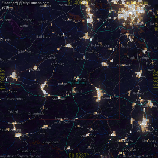
Analysis of Eisenberg night lights 2016
Square area 10x10 km:
 0.7%
0.7%90-99
0.42%80-89
0.42%70-79
0.98%60-69
0.84%50-59
0.56%40-49
0.56%30-39
0%20-29
0%10-19
0.7%0-9
94.82%Square area 50x50 km:
0.73%90-99
0.84%80-89
0.43%70-79
0.42%60-69
0.38%50-59
0.66%40-49
0.35%30-39
0.46%20-29
0.5%10-19
3.15%0-9
92.08%Clear (daylight) street map image can be seen on geolist.org.
Map coordinates:
51° 24' 33.4" North, 11° 11' 56.2" East
50° 58' 7" North, 11° 54' 7.5" East
50° 31' 25.3" North, 12° 36' 18.7" East
Some cities around Eisenberg sort by population:
• Jena
22.3 km =13.9 mi,  258°
258°
• Gera
16 km =9.9 mi,  127°
127°
• Naumburg
21.2 km =13.2 mi,  342°
342°
• Zeitz
18.7 km =11.6 mi,  61°
61°
• Hermsdorf
8.6 km =5.3 mi,  202°
202°
• Stadtroda
17.5 km =10.9 mi,  224°
224°
• Bad Kösen
22.3 km =13.9 mi,  325°
325°
• Ronneburg
23.1 km =14.4 mi,  120°
120°
2931521 (p: 11,438)
Sources (retrieved 2019-11-25):
» Earth at Night: Flat Maps 2012, 2016