Cölbe night lights from space
Night Light of Cölbe (Hesse) from space (Germany) Src. Average luminocity for 10x10km area is 9.7045% and for 50x50km: 1.4158%.
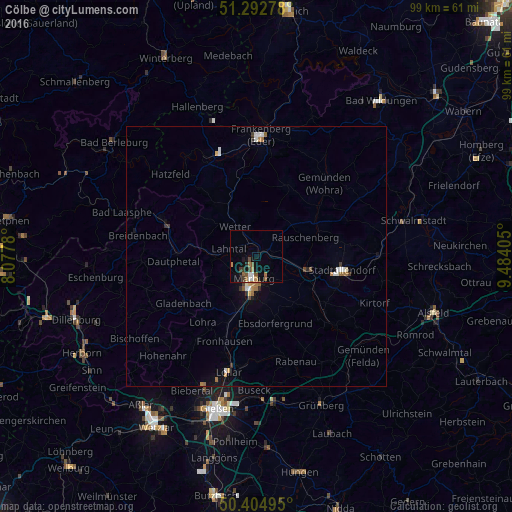
Analysis of Cölbe night lights 2016
Square area 10x10 km:
 1.26%
1.26%90-99
0.98%80-89
0%70-79
1.12%60-69
2.24%50-59
2.38%40-49
1.4%30-39
1.82%20-29
0.7%10-19
5.74%0-9
82.35%Square area 50x50 km:
0.19%90-99
0.22%80-89
0.04%70-79
0.16%60-69
0.34%50-59
0.16%40-49
0.14%30-39
0.22%20-29
0.11%10-19
0.6%0-9
97.8%Clear (daylight) street map image can be seen on geolist.org.
Map coordinates:
51° 17' 34" North, 8° 4' 40.1" East
50° 51' 3.5" North, 8° 46' 51.3" East
50° 24' 17.8" North, 9° 29' 2.6" East
Some cities around Cölbe sort by population:
• Marburg an der Lahn
4.7 km =2.9 mi,  188°
188°
• Stadtallendorf
16.6 km =10.3 mi,  100°
100°
• Kirchhain
10.7 km =6.6 mi, 104°
• Biedenkopf
18.8 km =11.7 mi,  290°
290°
• Gladenbach
16.8 km =10.4 mi,  236°
236°
• Wetter
7 km =4.3 mi,  324°
324°
• Lohra
16.7 km =10.4 mi,  218°
218°
• Amöneburg
11.7 km =7.3 mi,  121°
121°
2939942 (p: 7,083)
Sources (retrieved 2019-11-25):
» Earth at Night: Flat Maps 2012, 2016