Kirchhain night lights from space
Night Light of Kirchhain (Hesse) from space (Germany) Src. Average luminocity for 10x10km area is 1.8866% and for 50x50km: 1.5907%.
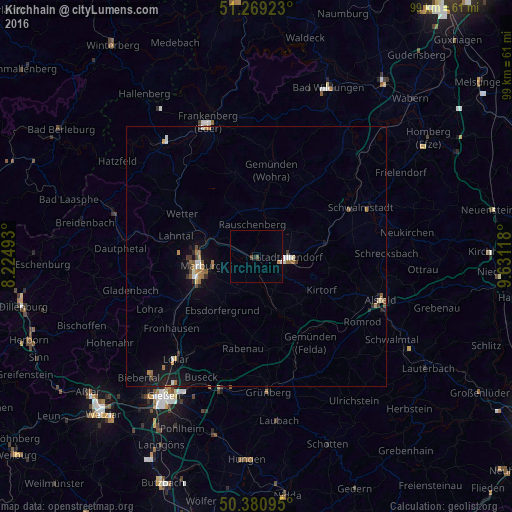
Analysis of Kirchhain night lights 2016
Square area 10x10 km:
 0.14%
0.14%90-99
0.14%80-89
0%70-79
0.56%60-69
0%50-59
0%40-49
1.12%30-39
0%20-29
0.56%10-19
0%0-9
97.48%Square area 50x50 km:
0.17%90-99
0.19%80-89
0.08%70-79
0.17%60-69
0.39%50-59
0.21%40-49
0.18%30-39
0.2%20-29
0.16%10-19
1.21%0-9
97.05%Clear (daylight) street map image can be seen on geolist.org.
Map coordinates:
51° 16' 9.2" North, 8° 13' 29.7" East
50° 49' 37.9" North, 8° 55' 41" East
50° 22' 51.4" North, 9° 37' 52.2" East
Some cities around Kirchhain sort by population:
• Marburg an der Lahn
11.2 km =7 mi,  259°
259°
• Stadtallendorf
6 km =3.7 mi,  94°
94°
• Wetter
16.6 km =10.3 mi,  300°
300°
• Neustadt (Hessen)
13.5 km =8.4 mi,  79°
79°
• Homberg
11.7 km =7.3 mi,  155°
155°
• Cölbe
10.7 km =6.6 mi,  284°
284°
• Amöneburg
3.5 km =2.2 mi,  185°
185°
• Rabenau
17.2 km =10.7 mi,  195°
195°
2890504 (p: 16,381)
Sources (retrieved 2019-11-25):
» Earth at Night: Flat Maps 2012, 2016