Haselhorst night lights from space
Night Light of Haselhorst (Berlin) from space (Germany) Src. Average luminocity for 10x10km area is 75.5238% and for 50x50km: 35.8299%.
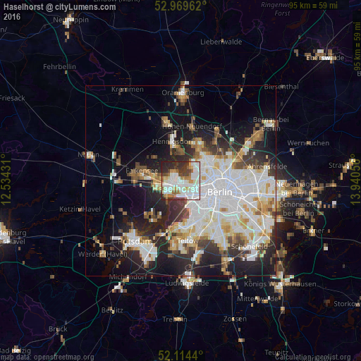
Analysis of Haselhorst night lights 2016
Square area 10x10 km:
 26.06%
90-99
26.46%80-89
4.63%70-79
5.95%60-69
8.2%50-59
3.17%40-49
7.14%30-39
7.54%20-29
10.32%10-19
0.53%0-9
0%Square area 50x50 km:
10.78%90-99
9.13%80-89
3.5%70-79
2.76%60-69
3.05%50-59
3.14%40-49
3.44%30-39
3.97%20-29
7.88%10-19
13.06%0-9
39.29%Clear (daylight) street map image can be seen on geolist.org.
Map coordinates:
52° 58' 10.6" North, 12° 32' 3.5" East
52° 32' 38.7" North, 13° 14' 14.7" East
52° 6' 51.8" North, 13° 56' 26" East
Some cities around Haselhorst sort by population:
• Charlottenburg
4.4 km =2.7 mi,  134°
134°
• Westend
4 km =2.5 mi,  138°
138°
• Wilhelmstadt
4.6 km =2.9 mi,  242°
242°
• Spandau
2.7 km =1.7 mi,  286°
286°
• Hakenfelde
2.6 km =1.6 mi,  309°
309°
• Charlottenburg-Nord
4.1 km =2.5 mi,  111°
111°
• Siemensstadt
1.8 km =1.1 mi,  102°
102°
• Konradshöhe
4.6 km =2.9 mi,  351°
351°
2909794 (p: 13,624)
Sources (retrieved 2019-11-25):
» Earth at Night: Flat Maps 2012, 2016