Neubulach night lights from space
Night Light of Neubulach (Baden-Württemberg) from space (Germany) Src. Average luminocity for 10x10km area is 1.7827% and for 50x50km: 8.3031%.
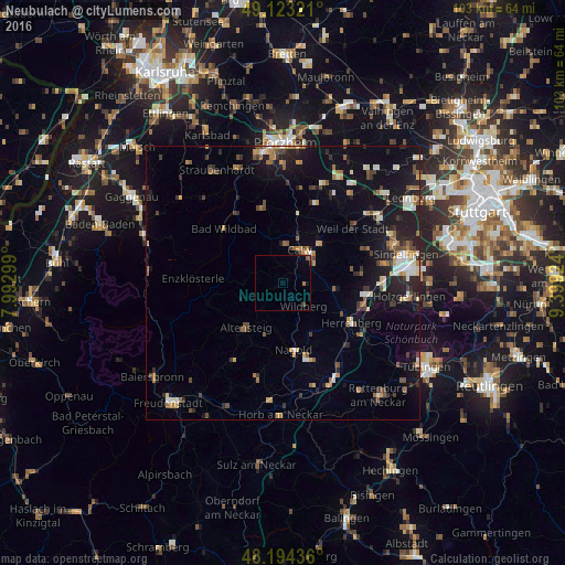
Analysis of Neubulach night lights 2016
Square area 10x10 km:
 0%
0%90-99
0%80-89
0%70-79
0%60-69
0.6%50-59
0.6%40-49
0%30-39
0.6%20-29
0%10-19
0.6%0-9
97.62%Square area 50x50 km:
0.75%90-99
1.11%80-89
0.78%70-79
0.97%60-69
1.07%50-59
1.08%40-49
1.2%30-39
1.32%20-29
2.31%10-19
6.75%0-9
82.66%Clear (daylight) street map image can be seen on geolist.org.
Map coordinates:
49° 7' 23.6" North, 7° 59' 34.8" East
48° 39' 39.3" North, 8° 41' 46" East
48° 11' 39.7" North, 9° 23' 57.3" East
Some cities around Neubulach sort by population:
• Herrenberg
14.5 km =9 mi,  120°
120°
• Calw
6.8 km =4.2 mi,  28°
28°
• Nagold
12.5 km =7.8 mi,  170°
170°
• Altensteig
10.7 km =6.6 mi,  219°
219°
• Wildberg
5.5 km =3.4 mi,  139°
139°
• Bad Liebenzell
12.8 km =8 mi,  11°
11°
• Schömberg
14.5 km =9 mi,  345°
345°
• Althengstett
10 km =6.2 mi,  46°
46°
2866086 (p: 5,540)
Sources (retrieved 2019-11-25):
» Earth at Night: Flat Maps 2012, 2016