Aidlingen night lights from space
Night Light of Aidlingen (Baden-Württemberg) from space (Germany) Src. Average luminocity for 10x10km area is 16.0595% and for 50x50km: 20.9903%.
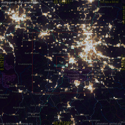
Analysis of Aidlingen night lights 2016
Square area 10x10 km:
 1.34%
1.34%90-99
2.83%80-89
1.64%70-79
0.74%60-69
0.89%50-59
2.98%40-49
0.6%30-39
4.76%20-29
3.87%10-19
24.26%0-9
56.1%Square area 50x50 km:
3.69%90-99
4.41%80-89
1.94%70-79
2.27%60-69
2.79%50-59
2.33%40-49
2.54%30-39
2.87%20-29
5.4%10-19
12.25%0-9
59.52%Clear (daylight) street map image can be seen on geolist.org.
Map coordinates:
49° 8' 26.2" North, 8° 11' 31.6" East
48° 40' 42.6" North, 8° 53' 42.9" East
48° 12' 43.5" North, 9° 35' 54.1" East
Some cities around Aidlingen sort by population:
• Böblingen
8.6 km =5.3 mi,  87°
87°
• Weil der Stadt
8.1 km =5 mi,  347°
347°
• Gärtringen
4.1 km =2.5 mi,  174°
174°
• Magstadt
9 km =5.6 mi,  35°
35°
• Althengstett
8.9 km =5.5 mi,  303°
303°
• Ehningen
4 km =2.5 mi,  122°
122°
• Grafenau
4.2 km =2.6 mi,  17°
17°
• Nufringen
6.2 km =3.9 mi,  183°
183°
2958904 (p: 9,285)
Sources (retrieved 2019-11-25):
» Earth at Night: Flat Maps 2012, 2016